|
©The Archaeological Settlements of Turkey - TAY Project
|
|
|
|
|
|
Bahadirli |
|
|
For site maps and drawings please click on the picture...  |
For photographs please click on the photo... 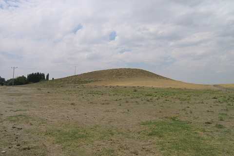 |
|
Type:
|
Mound |
|
Altitude:
|
1040 m |
|
Region:
|
Central Anatolia |
|
Province:
|
Konya |
|
District:
|
Kulu |
|
Village:
|
Bahadirli |
|
Investigation Method:
|
Survey |
|
Period:
|
Late Iron Age |
|
|
|
 |
|
| It lies 7 km southeast of the Kulu Town, within the borders of the Bahadirli Village in the Kulu District of Konya. It was discovered during the Central Anatolian Survey conducted by S. Omura in 1992. It measures ca. 260 m in diameter and 22 m in height. A brook flows through the southern skirt of the mound. Sherds collected from the surface are from the first half of the 1st Millennium BC. Also found are a limited number of sherds dating to the Early Bronze Age. Traces of settlement are also observed on the natural elevation to the south of the mound. Sherds collected from this section are from the second half of the 1st Millennium BC. H. Bahar reports presence of sherds from the Late Iron Age. It is listed in the inventory of registered archaeological sites prepared by Ministry of Culture and Tourism. It was visited during the survey conducted by H. Bahar and his team in 2012. During this survey, Bahar stated that the mound measures 100x100x25 m. Potsherds belonging to EBA, 2nd millennium BC, IA, Hellenistic and Roman periods were determined [Bahar 2014:261]. |
| Location: |
| Geography and Environment: |
| History: |
| Research and Excavation: |
| Stratigraphy: |
| Small Finds: |
| Remains: |
| Interpretation and Dating: |