|
©The Archaeological Settlements of Turkey - TAY Project
|
|
|
|
|
|
Kenan Tepe |
|
|
For site maps and drawings please click on the picture... 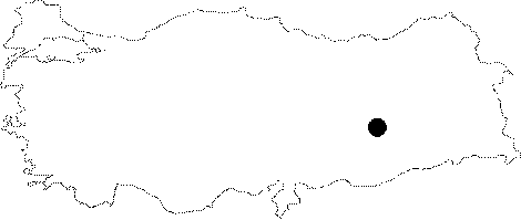 |
For photographs please click on the photo... 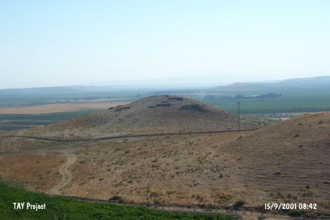 |
|
Type:
|
Mound |
|
Altitude:
|
530 m |
|
Region:
|
Southeastern Anatolia |
|
Province:
|
Diyarbakir |
|
District:
|
Bismil |
|
Village:
|
Kenan |
|
Investigation Method:
|
Excavation |
|
Period:
|
Early Iron Age |
|
|
|
 |
|
| Location: The site is located about 15 km east of the Bismil District in Diyarbakir Province; close to the Diyarbakir-Batman motorway. |
| Geography and Environment: Kenan Tepe is a large multi-period site composed of a tall central mound and extensive lower town stretching off to the northeast of the main mound. The site lies on a natural terrace and the top of the main town is 56.3 m above the Tigris River. The visible mounding extends for 225 m from southeast to northwest and 350 m from southwest to northeast. The Tigris River flows to the east of the mound and the road leading to the mound runs to the west. To the southeast; the village of Sefalik can be seen on a hill. |
| History: |
| Research and Excavation: Kenan Tepe was first documented in 1988 during the survey conducted in the region by a team under the direction of G. Algaze. The excavations were initiated in 2000 by B. Parker and his team within the scope of the Salvage Project of the Archaeological Heritage of the Ilisu and Carchemish Dam Reservoirs Activities carried out by ODTÜ TAÇDAM. Since 2005, it has been carried out under the direction of the Museum of Diyarbakir with the participation of B. Parker. It takes place in the registered archaeological sites list prepared by Ministry of Culture and Tourism. |
| Stratigraphy: The first excavations at Kenan Tepe, which was a multi-period settlement consisting of a high main mound and an expansive Lower City extending towards the northeast of the mound, showed that the mound had been occupied within four broad periods: Late Chalcolithic, first half of Early Bronze Age, early 2nd Millennium and Early Iron Age [Parker et al. 2004b:548-549]. The Early Iron Age settlement was identified based on the pottery with grooved rims Parker et al. 2003a:6]. |
| Small Finds: Architecture: It was revealed that the Area B is very rich in fragments of corrugated bowls dating to the Early Iron Age. The excavations at trenches B1 and B2 in the Area B yielded a wall with a stone foundation at trench B1. The finds uncovered in this area are dated to the Early Iron Age, and they include various domestic artifacts such as five mortars, one pestle, two pot smashes, and four rounded stones with a central hole. The rounded stones measure an average of 13 cm in diameter. Their size and weight suggest that they might have been used as weights for fishing nets rather than loom weights. The soil samples from this and other surfaces by means of flotation technique provide information about the significance of fishing for feeding and nourishing the inhabitants of Kenan Tepe during the Early Iron Age. Remains of an oven uncovered with the earthen floor clearly indicate daily use of these layers [Parker et al. 2002:615]. Among the architectural finds in trench B2 is the exterior wall of an Early Iron Age structure lying to the northeast of the trench B2. L2020 and L2013, which have been better preserved than this wall may represent other parts of the structure. The packed earth surfaces and pits to the south side of L2029, and to the west of L2020 represent work areas outside this structure. Some grindstones made of basalt indicate that it was a domestic structure [Parker et al. 2002:615]. The walls uncovered at trenches C3 and C4 should have belonged to a very large house or a public building. Trench B4 yielded a large pile of stones, which probably belonged to another large building or a fortification wall. Also found are evidences of metal working during the Early Iron Age. In Area C, several slags, ovens and open air workshops were uncovered, and majority of the slags which were analysed is iron [Parker et al. 2004:556]. Area B lies on the western slope of Kenan Tepe with a gently inclination, approximately 20 m west of Area A. Two trenches of 5x5 m were opened at a distance of 10 m in this area. And the excavations at Area B revealed that architectural remains of the Early Iron Age were mainly localized in this section of the mound [Parker-Dodd 2004:473]. When several deposits were removed under the pot smash uncovered during the excavation and mentioned above, a mudbrick wall strecthing roughly in the east-west direction was exposed. Also found is a second diagonally intersecting wall, but in less preserved condition. The first wall consists of two rows of rectangular blocks (ca.17x32 cm) and a row of square blocks at the center (ca. 32cm on sides). The collapsed layers were found on both sides of the wall while parts of a surface and oven residues are on the northern section. To the south of the wall are several pits. All these deposits include numerous varieties of Early Iron Age pottery [Parker et al. 2002:615]. During the excavations at trenches C3 and C4 in 2001, the Eraly Iron Age layers were identified with a few tandoor type of ovens. Area C lies northwest of Area B. In 2000, two trenches of 5x5 were opened in this area. After various layers of mixed deposits and disturbed remains, Trench C1 yielded a domestic structure, presumably dating earlier than the Early Iron Age layers already uncovered in trenches B1, B2 and C2 [Parker et al. 2002:616]. It is believed that numerous pits mentioned above may have belonged to a migrating hearth. This area with oven is located immediately to the southwest of the well-preserved curving mud brick wall (L2014). Deposit of this wall included a wide variety of Early Iron Age pottery including several examples of corrugated bowls and a banded vessel with handles. The trench is intersected with another straight mudbrick wall from the southwestern corner. The curving wall connects to the south of the trench with a packed mudbrick surface. There are two small pits in the southeastern corner of the trench, one with a red floor, and the other with an extremely hard layer of earth and bowls. The slags uncovered around it indicate presence of a metal-melting oven sufficient to have met the requirements of the village [Parker et al. 2002:616]. Due to traces of erosion observed on Kenan Tepe, it is possible that some architectural remains dating to the Early Iron Age may have been lost, particularly from the steep eastern and northern slopes of the main mound. The largest extent of the settlement during the Early Iron Age was probably around 2.7 acres. When the Early Iron Age settlement of Kenan Tepe is considered, presence of an indigenous Anatolian villages is obvious. Pottery: The uppermost level of trench B2, dated to the Early Iron Age as trench B, included a mixed deposit of various Hellenistic and Early Iron Age pottery. A major find of this trench is a pot smash uncovered on the packed earth surface. The excavations in trench B4 in Area B yielded numerous Early Iron Age ceramics. Furthermore, a well-preserved oven is also dated to the same period with ceramics. In trenches C1 and C2 of Area C, trench C2 yielded a structure dating to the Early Iron Age together with corrugated pottero of Iron Age [Parker et al. 2003:3]. Inside the wall which also yielded a figurine is full of various Iron Age ceramics [Parker et al. 2002:335-344]. Kenan Tepe hosted a developed settlement during the Early Iron Age, which can be observed in Area B and C with abundant number of remains. Among these finds are "corrugated wares" and "Indigenous Iron Age" ware described based on the survey material from the Upper Tigris Region. Although many of the contexts related with this period are disturbed due to proximity to the ground surface, the nature of the Early Iron Age settlement can still be evaluated [Parker et al. 2004:556]. Figurine: Trench C2 also yielded traces of Early Iron Age. To the west of the trench, three overlapping pits with concentrated loose ashy soil in one third of the area were found. Abundant number of bones and an animal figurine were found in these pits. The figurine was decorated with brownish-grey painted lines. The most significant area here lies to the southwest of the well-preserved rounded mudbrick wall [Parker et al. 2002:616]. |
| Remains: |
| Interpretation and Dating: There is an interruption in the occupations at Kenan Tepe during the Late Bronze Age. During the Early Iron Age (ca.1100-900 BC) Kenan Tepe again hosted a developed settlement. Remains of this period can be abundantly observed in Areas B and C. However, no traces of Iron Age remains are available in the Lower City and eastern slopes of the main mound (Area D). As described above, some sections of Kenan Tepe were lost to erosion. Thus, it is likely that some of the Early Iron Age remains may have been eroded and disappeared, which can be observed particularly on the steep eastern and northern slopes of the main mound. Under these conditions, it is difficult to have a precise information on the size of the Early Iron Age settlement. However, we are sure that the largest extent of the main mound during the Early Iron Age occupation at Kenan Tepe didn't exceed 2.7 acres. However, if the remains from the Early Iron Age have not been severely disturbed by erosion, then we can conclude that it was a little bit smaller settlement [Parker et al. 2004:556]. |