|
©The Archaeological Settlements of Turkey - TAY Project
|
|
|
|
|
|
Bagliksirti |
|
|
For site maps and drawings please click on the picture...  |
For photographs please click on the photo... 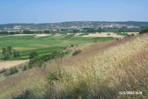 |
|
Type:
|
Slope Settlement |
|
Altitude:
|
15 m |
|
Region:
|
Marmara |
|
Province:
|
Edirne |
|
District:
|
Meriç |
|
Village:
|
Seren |
|
Investigation Method:
|
Survey |
|
Period:
|
Early Iron Age |
|
|
|
 |
|
| It is located about 2 km southwest of the village of Seren (Serem); district of Meriç; province of Edirne. It lies on the hill on the western side of the road near the mosque of Serem Village; 1.1 km after the road and 15.8 km after the village of Kavakli. Gavurdere/Kanlidere stream flows under the slope; between the slope and the fields. The plain can be seen to the southwest of the settlement and to the west; in the area where the plain ends; the Meriç River and the border. The tumulus of Üveyiktepe/Hüyüktepe; which is the border between the villages of Rahmança and Seren; lies on the ridges to the southwest. It was discovered by B. Erdogu during a survey conducted in 1997. It has been heavily destroyed due to intense cultivation. Sherds of "Maslidere" pottery and limited number of Early Iron Age pottery were collected from an area of ca. 50x50 m. |
| Location: |
| Geography and Environment: |
| History: |
| Research and Excavation: |
| Stratigraphy: |
| Small Finds: |
| Remains: |
| Interpretation and Dating: |