|
©The Archaeological Settlements of Turkey - TAY Project
|
|
|
|
|
|
Tell el Cüdeyde |
|
|
For site maps and drawings please click on the picture...  |
For photographs please click on the photo... 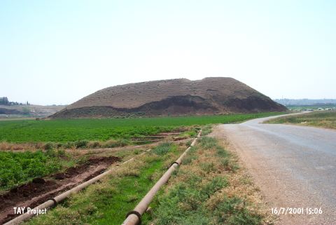 |
|
Type:
|
Mound |
|
Altitude:
|
220 m |
|
Region:
|
Mediterranean |
|
Province:
|
Hatay |
|
District:
|
Reyhanli |
|
Village:
|
Merkez |
|
Investigation Method:
|
Excavation |
|
Period:
|
|
|
|
|
 |
|
| It is situated 1.8-1.9 km east-southeast of the Reyhanli District, southeast of Antakya. Tell el Cüdeyde had been inhabited from the Neolithic Age until the Islamic Period. The stratification that was enumerated from I to XIV played an important role in the evaluation of the Survey of the Amuqe Plain until the day the excavation results were published. It takes place in the registered archaeological sites list prepared by Ministry of Culture and Tourism. |
| Location: The site lies southeast of Antakya; 1.8-1.9 km east-southeast of Reyhanli District. |
| Geography and Environment: The site is one of the biggest mounds in Amuq Plain; on which; more than 200 settlements; dating to various periods; are located due to the most recent survey. The site; surrounded by fertile lands irrigated by the branches of Afrin Stream; is convenient for settling. The mound measures 370 m in East-West axis; 250 m n North-South axis; and 31 m high above the level of the plain. A desiccated lake is located at the north. A creek; named Kizil Ark or Nahr el Cüdeyde; flows east of the mound. This creek was most probably used as a water source by the inhabitants. The site is observed to be severely damaged like the other mounds in Amuq Plain. A mudbrick wall; probably a fortification; has been revealed by a bulldozer; and is about to vanish. Amuq Plain (named incorrectly as Amuq Plain in the archaeological publications) lies east of Amanos Ranges; and covers an approximate area of 55x40 km. The plain reaches the Mediterranean on the southwestern extension. The ardent lands of Northern Syria; like deserts with low hills; lie east of Amuq Plain. Orontes and its branches not only irrigate the plain; but create fertile lands by the alluvium it accumulates. The site is more convenient in climate for settling; compared to Northern Syria. |
| History: |
| Research and Excavation: |
| Stratigraphy: |
| Small Finds: |
| Remains: |
| Interpretation and Dating: |