|
©The Archaeological Settlements of Turkey - TAY Project
|
|
|
|
|
|
Ekrek 3 |
|
|
For site maps and drawings please click on the picture...  |
For photographs please click on the photo... 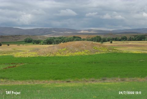 |
|
Type:
|
Mound |
|
Altitude:
|
1470 m |
|
Region:
|
Central Anatolia |
|
Province:
|
Kayseri |
|
District:
|
Bünyan |
|
Village:
|
Köprübasi |
|
Investigation Method:
|
Survey |
|
Period:
|
|
|
|
|
 |
|
| It lies in Zakalti Mevkii; 2.2 km north of Köprübasi(Ekrek) Village; southeast of Bünyan; east of Kayseri Province. A water channel locates east of the mound. It was discovered in 1972. It is a conic mound. It measures 8 m in height and 70x90 m in dimensions. According to G.H. Brown; samples of simple ware dating to the EBA; Alisar III ware and imported ware were collected from the surface. It is reported that the site had been inhabited from the EBA to the Classical Period. It was called Ekrek III as there were two more settlements in the vicinity of Ekrek Village. It was revisited during the survey conducted by Kulakoglu and his team in 2010. A 2.5 m high stone wall was seen on one of the illicit digging pits. Large amount of EBA wares were collected from the surface of the mound. Among these, there are pothsherds belonging to Alisar III Period. A few MBA and IA sherds were also found [Kulakoglu et al. 2012:216]. |
| Location: |
| Geography and Environment: |
| History: |
| Research and Excavation: |
| Stratigraphy: |
| Small Finds: |
| Remains: |
| Interpretation and Dating: |