|
©The Archaeological Settlements of Turkey - TAY Project
|
|
|
|
|
|
Ekrek 1 |
|
|
For site maps and drawings please click on the picture...  |
For photographs please click on the photo... 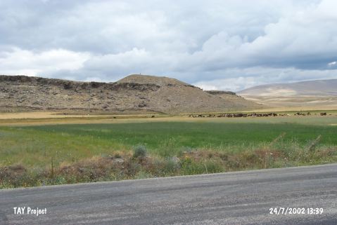 |
|
Type:
|
Mound |
|
Altitude:
|
1490 m |
|
Region:
|
Central Anatolia |
|
Province:
|
Kayseri |
|
District:
|
Bünyan |
|
Village:
|
Köprübasi |
|
Investigation Method:
|
Survey |
|
Period:
|
|
|
|
|
 |
|
| It lies about 2.5 km east of Köprübasi (Ekrek) Village; west of Pazarören; southeast of Bünyan; east of Kayseri Province. The mound is known as Kalecik at Çügenlik Mevkii. It is situated north of the highway. It measures 8 m in height and 60x70 m in dimensions. It is reported that it stands on a rocky block. It has a natural defense since the southern and eastern slopes are steep. The conical top hill has been partly destroyed. During the surface collection conducted by D.H. French in 1962; and then by G.H. Brown in 1965; sherds of simple and red washed ware and simple Alisar III ware belonging to the EBA were collected. Besides imported ware; sherd of a pithos stamped by a metallic seal is an outstanding piece among the material collected. It also covers a settlement of the second millennium BC During the survey conducted by Meriggi in this region; it was called Kalecik while G.H. Brown called it Mound No.1 as there were two other settlements in the surrounding territory. |
| Location: |
| Geography and Environment: |
| History: |
| Research and Excavation: |
| Stratigraphy: |
| Small Finds: |
| Remains: |
| Interpretation and Dating: |