|
©The Archaeological Settlements of Turkey - TAY Project
|
|
|
|
|
|
Miyadin / Köyanala |
|
|
For site maps and drawings please click on the picture...  |
For photographs please click on the photo... 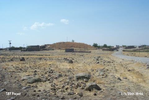 |
|
Type:
|
Mound |
|
Altitude:
|
760 m |
|
Region:
|
Southeastern Anatolia |
|
Province:
|
Diyarbakir |
|
District:
|
Ergani |
|
Village:
|
Koyunalan |
|
Investigation Method:
|
Survey |
|
Period:
|
Protogeometric |
|
|
|
 |
|
| It is 15 m high, measuring 150 m long in north-south direction, and 100 m long in east-west direction. Except the east, northeast and north sections, the slopes have been occupied by a modern settlement. It is also known as Miyadin, Mayadun or Köyanala. It is likely to house plain ware, and similarly red slipped, burnished and wheelmade ware belonging to the first half of the 1st Millennium BC (particularly known from Nimrut, Tell Halaf's Kabara level, Amique phase O, Hama Syro-Hittitian level and Palestine Early Iron Age II). |
| Location: |
| Geography and Environment: |
| History: |
| Research and Excavation: |
| Stratigraphy: |
| Small Finds: |
| Remains: |
| Interpretation and Dating: |