|
©The Archaeological Settlements of Turkey - TAY Project
|
|
|
|
|
|
Masat Höyük |
|
|
For site maps and drawings please click on the picture...  |
For photographs please click on the photo... 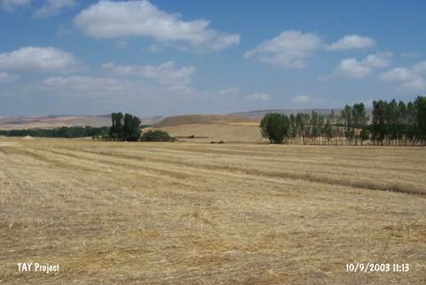 |
|
Type:
|
Mound |
|
Altitude:
|
950 m |
|
Region:
|
Black Sea |
|
Province:
|
Tokat |
|
District:
|
Zile |
|
Village:
|
Yalinyazi |
|
Investigation Method:
|
Excavation |
|
Period:
|
|
|
|
|
 |
|
| Location: It lies 1500 m west of the Masat Village (Yalinyazi); 20 km south-southwest of the Zile District; southwest of Tokat Province. |
| Geography and Environment: Streams originating from the village the mound were named after; located north of the mound in the fertile land of the Masat Plain spill to the Çekerek River. The inhabitants of this settlement were probably supplying their water from these resources. At present; there is no fresh water spring around. The mound was formed on marble-like limestone blocks. It was probably chosen as a mainland because of the elevation of this rocky ground. It is an oval shaped mound; 28.8 m high above the plain level; 450 m long in the east-west direction and 225 m long in the north-south direction. It is classified among the biggest mounds of Central Anatolia. Virgin soil was reached at 5.7 m depth during the first excavations [Akurgal 1946:220]. |
| History: |
| Research and Excavation: It became famous in 1943 when a Hittite tablet was recovered from the surface and published. The initial excavations were conducted by a delegation consisting of T. and N. Özgüç and Y. Boysal under the direction of E. Akurgal in 1945. The main objective of the excavation was to uncover the archive related with this tablet. Based on this written source, it became known that the site was a city called Tapigga during the 2nd Millennium BC. After a long pause, the excavations were continued between 1973 and 1980 under the direction of T. Özgüç. Recent excavations mainly focused on the Hittite Period. It is listed among the registered archaeological sites by the Ministry of Culture and Tourism. |
| Stratigraphy: The excavations revealed that the site had been inhabited from the Early Bronze Age until the Iron Age. Also a Late Chalcolithic Age/Early Bronze Age I settlement may be present. The first layer is dated to the Iron Age while the second and third layers to the Hittite Period, and following layers to the Early Bronze Age [Özgüç 1978:3]. |
| Small Finds: Architecture: During the Iron Age, the central, northern, northeastern and eastern sections (D-H/3-6) of the fortress had been intensely occupied. The plan-squares I/4-6 and H/6-7 mainly represent areas of wells. It seems that unlike other Iron Age cities in Anatolia, it was not fortified. The Phrygians occupied only the fortress area, but didn't settled in the lower city. There are three Phrygian building levels (I-III). The lowest level (III) was constructed over the debris of the Hittite Palace. The domestic structures have been preserved better than the levels I and II. They were built adjacent to each other on the northern ridge of the hill. Their small and irregular courtyards can be observed in the plan-sqaures E/5-6 and F/6 over the courtyard of the palace. In plan-squares E-F/3-4, there are two well-preserved domestic structures. The inner and outer surfaces of the stone foundations were built with mud mortars, and filled with rubble stones and earth. The walls were erected with rectangular mudbricks. The mudbricks are usually large in size; mostly 40x30x6 cm in dimensions. The rooms and domestic structures are in rectangular plan; very few in square plan. The floors of the rooms are of compressed soil. The domestic structure in a rectangular plan with two rooms uncovered at E-F/3-4 measures 16 m in lenght, and 6 m in width, mainly with a mudbrick masonry. The walls are 70 cm thick. The stone walls rise for 1 m above the floor level. The hearth floor was preserved in the small room (5.8x3.3 m) at F/3. The southern walls of the shorter axis at E-F/4-5 have been destroyed by the stone foundations of the overlaying building level II. Unlike many Phrygian houses, the walls were connected at perpendicular angles. The floor of the narrow and long section at F/3-4 was paved with pebbles and hard soil. It is believed that this section between the two houses had no roof. The channel of the Phrygian building level II was constructed over this section of the house. Both sides of this late channel was laid with large stones which were removed from the Hittite structures, and then surmounted by flat stones; the floor is of soil. The channel conveyed waste waters of the Phrygian houses on the hilltop downwards through the northern ridge. Two stone banks plastered with a thick loam were found in situ in front of the east and west walls of the large room (8.5 x 3.5 m) at F/4. Majority of the traditional intact vessels was found in the first room around the hearth floor. The domestic structures of the building level III, which appears to have extended downwards from the northern ridge of the hill, have been destroyed afterwards with only small and truncated foundations left to the present. The second domestic structure to the west of this house is 15 m long, and 4.5 m wide. The masonry and material are similar to the first one. However, the outer walls are thinner than the walls of the first house (60 cm). The hearth at E-F/3-4 and the kiln at E/4 are well-preserved. The southern short axis of this structure was also destroyed by the stone foundations of the building level II. Three flat stones (E/4) define the street-door of the house. The first structure may also use this as front-entrance door. Unlike the other, the walls are not perpendicular to each other and the longer west wall becomes narrower from north to south (it is 4 m wide in the north and 3.5 m wide in the south), resulting in a very irregular trapezoidal shape. Although not all of them are so uneven, such structures are common in the Central Anatolia, particularly during the Phrygian Period. The charred wooden planks of the flat roof and mudbrick walls indicate that the domestic structures of the Phrygian building level III underwent a fire. These two structures compose a complex separated from others on this section of the hill. The second domestic structure is demarcated from another complex to the west (E/3-4) by a 1.5 m wide street with a preserved lenght of 11.5 m paved with flat stones. It seems that the street strecthed in north-south orientation, and its both ends as well as the largest section of the domestic structure beloning to the building level III to its west were demolished during the operations of the inhabitants of the building levels I and II. The plan of the domestic structures composing the second complex to the east at F-G/3-5 is uncertain. The damage caused by the inhabitants of the building level I and II on this side was extensive, resulting in destruction of not only the domestic structures of the Phrygian building level III, but also the major sections from the Hittite Period. Yet, presence of thick and thin foundations connected to each other, and rectangular rooms, some with flat stone paved floors can still be traced in this section. The upper parts of the stone floors observed in each building level are coated with loam. The 2 m wide street flanked by a row of stones with a peeble paved floor at F/5 was built during the building level III, and also used during the building level II. It appears that the street extends eastward stretching over the palatial portico and the palatial rooms with stone paved floors, reaching the outside. It is very likely that the town was accessed through this street. It seems that the street not paved with stones, but with plenty of pebbles and sand didn't get muddy during rainy seasons. Stretching from out of the town, this road was probably joining with the stone street demarcating the quarters at E/4. The domestic structures were mostly built on both sides of the narrow streets. It appears that at Masat Höyük the squares at plansquares D-F/6 was very narrow because of limited populated area. The small towns of the Phrygian fortresses are identical in the Central Anatolia. Masat Höyük provides an evidence of the expansion of this system northwards. It appears the limit of this system is represented by Akalan on the north (Black Sea shores). The domestic structures of the Phrygian building level III were directly built over the burnt mudbrick walls and debris of the palace. Furthermore, deep Phrygian pits with rounded mouth contributed to the destruction. The wells at plansquares G/3-4 and I/4-5 yielded broken tablets and bullae. At some sections, ths stone foundations of the palace served as floor of these wells. At this section there are no traces and remains of the Hittite building levels II and I between the Phrygian building level III and the palatial remains. Only rooms 4-6 of the colonnaded structure from the reign of Suppiluliuma were repaired during the Phrygian building level III, and used again with a minor modification. Abundant number of earlier pottery and metal works were uncovered from the floor of the domestic structures belonging to the Phrygian building level III. Based on them, this building level can be dated to a period between 750 BC and 650/600 BC. The domestic structures of the Phrygian Building level II were found as a group at D-G/3-5. The structures of this level which experienced a fire have been more destroyed. Their foundations and walls were mostly truncated. One of the streets is in situ while extension of the other is invisible. Although the plan of the domestic structures can be defined, it seems that the domestic structures with small rooms in previous rectangular shape were also built during that phase. The thin mudbrick walls of the building level III at E/4 remained under the thick stone foundations of the building level II, with a modification in the orientation. Floors of some rooms were paved with stones during that phase as it was in the previous phase. In some sections, the height of the stone foundations at this level reach up to 1.5 m, built with very large blocks. Although the latest two building levels represent period of the Achaemenid domination in Anatolia, local tradition of art uninterruptedly continued. However, some of the artifacts recovered from the building level II indicate that the Achaemeneid influence in Anatolia may have been more than thought so far. The foundations of the latest Phrygian level or building level I are 25-30 cm under the surface ground. As the foundations whose stones were removed were left in small, truncated fragments, no analysis was made on their plan. At E-G/4-5, the fragments of wall which intersect each other but without no extensions as they were in the building level II and partially preserved hard floors of the rooms indicate that the hill maintained the size of the two previous building levels, i.e. it was neither increased nor reduced in size. It appears that the thickness of the foundation ranged from 60 to 70 cm, with some partition walls being 50 cm thick. The stone paved large room with a dimension of 6.8x2 m remained like an island among the truncated foundations. Based on a few remains, it seems that a small domestic structure was built over the archives of the palace, and the wells increased destruction on the Hittite buildings mainly at I/6 and H/6. The domestric structures of the building level I were built immediately after the destruction of the building level II. There is no thick debris layer between the building levels. At Masat Höyük, the thickness of the three Phrygian building levels reach up to 5.5 m at the thickest point. Based on local and some imported goods, the building level I maintained its presence between 450 and 300 BC, and afterwards ruins of these structures remained open for ages, and served like a quarry for new cities and villages, which were founded in the vicinity and somewhere else. At Masat Höyük there exists no late occupation over the latest Phrygian building level. The site had not been inhabited during the Hellenistic, Roman, Byzantine, Seljuks and Ottoman Periods. Although it is not possible to explain it definitely, it may be interpreted that the newcomers might have preferred sites suitable to expand, with an open view, i.e. mountain ridges, near the fresh water resources and streams, being easy to fortify with wider terrains for settlement. For example, the village of Masat Köyü (Yalinyazi) was established on a flat plain on the banks of the stream, 1500 m east of the mound by the first Turkish tribes who immigrated from Meshed, the capital of Khorasan. The newcomers called the former city, which was situated just accross them with a forgotten name, as Höyüktepe, a name they used while they were in Iran and Central Asia instead of Harabe (ruins). Pottery: The pottery of Masat Höyük is parallel to the Central Anatolian pottery, particularly within the Kizilirmak Curve and to its south. It is also divided into groups as early, middle and late phase based on the building levels they were recovered from. This classification based on the building levels is also confirmed by the pottery technique, style of geometric patterns and animal depictions, and variety of colors used. During that age, only this type of pottery was used in the wide area remaining between Sivas-Malatya to the east, Kizilirmak (the Halys River) to the west, the Black Sea to the north, and the Eastern Taurus Mountains to the south. It is not easy to distinguish even local features among these pottery which look like as if they are from the same mould in such a wide region. The only exception is that local features become more prominent in the depiction of animals and hybrid creatures during the late phase of the pottery in the northern regions, resulting with an impact in the southern regions. A large majority of the Iron Age pottery, particularly the ones used during the late phase of the building level II and throughout the building level I represents pottery of the period under the Median and Persian Empires. The pottery of Masat Höyük can also be divided into three groups as paint-decorated, monochrome and utencils. Early phase pottery of the building level III are coarse and thick walled, decorated with monochrome animal and geometric patterns. The patterns are largely in two-colors during the intermediate and late phases (levels: 1-2). No difference is observed in the technique and forms of the monochrome and decorated pottery. Their paste are all tempered with fine sand. Except the smudged, coarse kitchen ware, they are all slipped and burnished. The painted pottery of the late phase have a new paneled decoration technique, uncommon in the earlier phase, with white or whitish cream paint on the slip. The motifs are depicted on this panel. Most of the pottery are slipped and burnished in colors ranging from reddish grey to light grey. The contrast between light colored slip and dark depictions give the motifs a vividness and brightness. The motifs of the embroidery pottery are mainly in red, black, brown and reddish brown. No difference is observed in the forms of the polychrome and monochrome ware. The earlier pottery forms persist during the late phase, only with emergence of new types of large pithoi and jugs, which were uncommon during the earlier phase. The forms of the polychrome and monochrome pottery of each phase include bowls, high handled cups, and mugs, trefoil jugs/spouted pitchers, vases, kraters and large pots/pithoi. Despite presence of depictions of deers, birds and trees, geometric motifs are dominant during the early phase. They usually decorate partly, particularly upper of the vessels. During the late phase, depictions of animals, hybrid creatures, birds, astrol motifs, dotted lines and plaits are common in addition to the geometric motifs. The rims of the bowls, cups and kraters as well as their lips are also decorated with geometric motifs. The handles of small vessels and kraters are paint decorated. The handles divide the panels on the body, which were, in turn, divided into subsidiary bands in the style of metopes. Number of vessels decorated with reliefs are very restricted. The forms include bowls, cups, jugs, kraters, vases, bucket handled teapots, pots with round bodies or small kettles, large vessels, utencils and lids. Bone: The artifacts of the Iron Age were all well-crafted and burnished, used for very fine work. The samples include bracelet, handle, awl, and plate. Clay: Among the finds are horsehead and discus. Fauna: The detailed analyses were performed on the bone assemblage handpicked from the Phrygian levels I and II, which are dated 450-300 BC and 700-450 BC, in Masat Höyük. The analyses show that the majority of bones belong to four domestic animals: cattle, sheep, goat and pig. In addition to this, horse bones were also encountered among the assemblage. 19 bones bear evidence of butchery, the majority of which are cattle bones [Ioannidou-Piskin:2013]. |
| Remains: |
| Interpretation and Dating: |