|
©The Archaeological Settlements of Turkey - TAY Project
|
|
|
|
|
|
Kürkçüler |
|
|
For site maps and drawings please click on the picture...  |
For photographs please click on the photo... 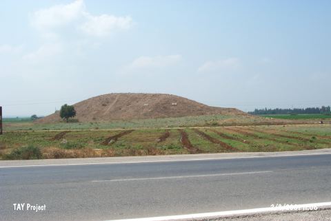 |
|
Type:
|
Mound |
|
Altitude:
|
70 m |
|
Region:
|
Mediterranean |
|
Province:
|
Adana |
|
District:
|
Merkez |
|
Village:
|
Merkez |
|
Investigation Method:
|
Survey |
|
Period:
|
|
|
|
|
 |
|
| It is situated 100 m south of the Adana-Yakapinar motorway, 6.6 km east of the Incirlik Village, west of the Yakapinar Subdistrict, approximately 17 km east of Adana. It has a height of 7-8 m with a flat top and terraces. It was investigated during the Neilsen Expedition in 1936 and identified as a Late Hittite settlement. Analysis on the sherds collected during the Cilicia Survey conducted under the direction of M.V.Seton-Williams indicated that it had been inhabited from the Early Bronze Age until the Byzantine Period, except the 2nd Millennium BC [Seton-Williams 1954:131-163; findspot 9]. It takes place in the registered archaeological sites list prepared by Ministry of Culture and Tourism. |
| Location: |
| Geography and Environment: |
| History: |
| Research and Excavation: |
| Stratigraphy: |
| Small Finds: |
| Remains: |
| Interpretation and Dating: |