|
©The Archaeological Settlements of Turkey - TAY Project
|
|
|
|
|
|
Kandilli / Bahçehisar |
|
|
For site maps and drawings please click on the picture...  |
For photographs please click on the photo... 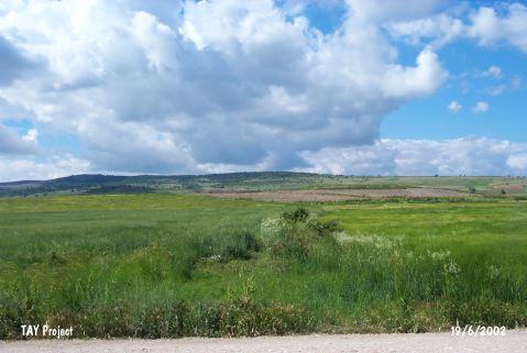 |
|
Type:
|
Mound |
|
Altitude:
|
820 m |
|
Region:
|
Marmara |
|
Province:
|
Bilecik |
|
District:
|
Bozüyük |
|
Village:
|
Kandilli |
|
Investigation Method:
|
Survey |
|
Period:
|
|
|
|
|
 |
|
| It is situated 5 km west of Inönü, south-southeast of the provincial center of Bilecik. Located in the western section of the Eskisehir Plain to the south of Sarisu, a small tributary of the Porsuk River, it is an oval shaped hill, 7.5 m high from the plain level at present. It extends 400 m in north-south direction, being one of the largest mounds in the region. The northern section is higher. There is a terrace in the southern section. The mound is known as Kandilli in the world of archaeology, but T. Efe reports that it is locally known as Bahçehisar. It was named after the village nearby by D.H. French [French 1968:sek. 35, no. 322], but a systematic survey was performed by T. Efe only in 1990 [Efe 1992:561]. Based on surface finds, the hill contains remains from the EBA II and III, early 2nd Millennium BC, Classical Period and Byzantine Period settlements. |
| Location: It lies 4.3 km northeast of Kandilli Village; 5 km west of Inönü; south-southeast of the Bilecik Province. |
| Geography and Environment: It is located on the western part of the Eskisehir Plain; south of Sarisu; a small branch of the Porsuk River. It is an oval hill; 7.5 m high above the plain level and 400 m long in the north-south direction. Northern part looks higher while southern part has a terrace. It was introduced as Kandilli; being named after the nearest village. However; T. Efe reports that it is locally known as Bahçehisar. It is one of the biggest mounds in the region. |
| History: |
| Research and Excavation: |
| Stratigraphy: |
| Small Finds: |
| Remains: |
| Interpretation and Dating: |