|
©The Archaeological Settlements of Turkey - TAY Project
|
|
|
|
|
|
Hesigin / Tülek |
|
|
For site maps and drawings please click on the picture...  |
For photographs please click on the photo... 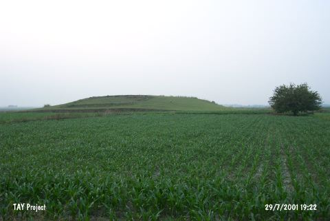 |
|
Type:
|
Mound |
|
Altitude:
|
100 m |
|
Region:
|
Mediterranean |
|
Province:
|
Adana |
|
District:
|
Ceyhan |
|
Village:
|
Kurtkulagi |
|
Investigation Method:
|
Survey |
|
Period:
|
|
|
|
|
 |
|
| It lies 6.6 km north of the Kurtkulagi (Kurtkuluk) Village, southeast of the Ceyhan District, east-southeast of the provincial center of Adana. It was discovered in 1951 by M.V. Seton-Williams and reinvestigated during the survey conducted in 1991 by the Bilkent University on the Cilician coastal plain. Also known as Hesigin, its actual name is reported as Tülek Höyük. The mound is 15 m high, with prominent terrrace levels. It has been heavily destroyed, and at present, it has been delimited by irigation channels. Other than settlements dating from the Early Bronze to the Roman Period, several sherds of slightly slipped ware with wiped surfaces resembling the Amuq F ware indicate presence of the Late Chalcolithic Age [Seton-Williams 1954:156]. It is listed among the registered archaeological sites prepared by the Ministry of Culture and Tourism. |
| Location: |
| Geography and Environment: |
| History: |
| Research and Excavation: |
| Stratigraphy: |
| Small Finds: |
| Remains: |
| Interpretation and Dating: |