|
©The Archaeological Settlements of Turkey - TAY Project
|
|
|
|
|
|
Habibusagi Kale |
|
|
For site maps and drawings please click on the picture...  |
For photographs please click on the photo... 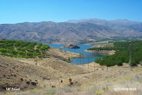 |
|
Type:
|
Mound |
|
Altitude:
|
710 m |
|
Region:
|
Eastern Anatolia |
|
Province:
|
Elazig |
|
District:
|
Baskil |
|
Village:
|
Habibusagi |
|
Investigation Method:
|
Excavation |
|
Period:
|
Middle Iron Age Early Iron Age |
|
|
|
 |
|
| Location: Kalenin dört bir yanı sarp kalker kayalıklarıyla çevrelenmiştir. Denizden yüksekliği 713 m'dir. Fırat Nehri'nin geçit verdiği noktaya yakınlığı ve kuzeydoğusundaki verimli vadiye olan hakimiyeti, kalenin stratejik önemini artırmaktadır. Günümüzde Karakaya Baraj Gölü'nün suları altında kalmıştır. |
| Geography and Environment: All four sides of the fortress were encircled with steep calcareous rocks. Its altitude is. Its closeness to Euphrates River passage point and its dominance on the abundant northeast valley, makes the fortress strategically even more important. At present it is under water inside the reservoir of Karakaya Dam. |
| History: |
| Research and Excavation: An excavation was conducted by B. Ögün at Habibusagi Fortress between 1982-83. |
| Stratigraphy: As a result of excavations it was observed that Habibusagi Fortress was inhabited during Early Iron Age and Middle Iron Age (Urartu). |
| Small Finds: Inscriptions: The most important document emphasizing the importance of the fortress at present is the inscriptions on the southeast surface of the rock in cuneiform. It clearly belongs to Urartu King Argistis' son Sardur. The epigraph is important due to its location at the westernmost spot within Urartu borders (See "Habibusagi Yaziti" record). Architecture: Two tunnels built inside the fortress, one was carved inside the north rock, and the other inside the west rock, and they both bear marks from Urartu period. There is only a small settlement west of the fortress. Adobe wall traces were unearthed due to illicit diggings. These have a height approximately of 2 m. Pottery: Early and Middle Iron Age sherds were found during excavations. Necropolis: A necropolis was found during excavations northeast of the fortress adjacent to the village. A grave with two urnes was unearthed. Urnes were covered on the top with two lid stones, and were covered around and at the top with other unidentical stones. Based on excavations these graves were dated to Early Iron Age. A spearhead was found next to one of the graves. |
| Remains: |
| Interpretation and Dating: It is very clear based on inscriptions found at Habibusagi Fortress that it was inhabited by Urartians. Besides, it is particularly important due to its location at the westernmost spot inside the dispersion area of Urartians. Unfortunately the excavations and studies on the fortress are insufficient. Presently it is under water inside the reservoir of Karakaya Dam. |