|
©The Archaeological Settlements of Turkey - TAY Project
|
|
|
|
|
|
Firaktin |
|
|
For site maps and drawings please click on the picture...  |
For photographs please click on the photo... 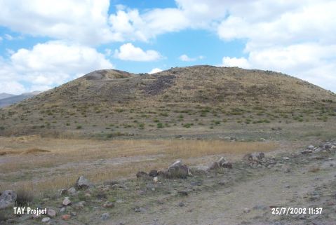 |
|
Type:
|
Mound |
|
Altitude:
|
1320 m |
|
Region:
|
Central Anatolia |
|
Province:
|
Kayseri |
|
District:
|
Develi |
|
Village:
|
Gümüsören |
|
Investigation Method:
|
Survey |
|
Period:
|
|
|
|
|
 |
|
| It lies to the north of the Gümüsören (Firaktin) Village, southeast of the Develi District, south of Kayseri. The settlement at Firaktin rests on the cape near the rock relief from the Hittite Period. It measures 150x80 m in dimensions, with a height of 15 m. It was excavated in 1947 by T. Özgüç; and in 1954 small soundings were conducted again by Özgüç in order to confirm the initial findings. Three cultural levels, Roman, Phrygian and Hittite Periods, were identified. Deep foundations of the three-phase Roman building level gave great harm to the Phrygian settlement, which consisted of small structures and underwent a fire during its last phase. Many remains of mud-brick and beams in the houses of the Early and Late Phrygian phases are observed. Among the restricted number of finds, important ones are painted and monochrome samples from the Early and Late Phrygian Periods and one stamp seal. The late phase of the two Hittite building levels underlying the Phrygian level ended up with a great fire. It takes place in the registered archaeological sites list prepared by Ministry of Culture and Tourism. |
| Location: |
| Geography and Environment: |
| History: |
| Research and Excavation: |
| Stratigraphy: |
| Small Finds: |
| Remains: |
| Interpretation and Dating: |