|
©The Archaeological Settlements of Turkey - TAY Project
|
|
|
|
|
|
Eskiköy Yeri |
|
|
For site maps and drawings please click on the picture...  |
For photographs please click on the photo... 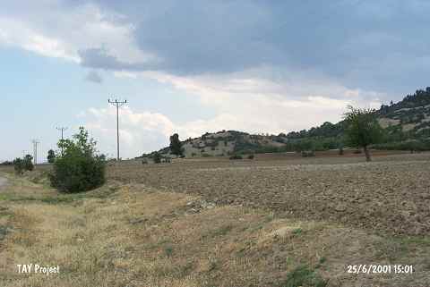 |
|
Type:
|
Upland Settlement |
|
Altitude:
|
950 m |
|
Region:
|
Mediterranean |
|
Province:
|
Antalya |
|
District:
|
Korkuteli |
|
Village:
|
Çomakli |
|
Investigation Method:
|
Survey |
|
Period:
|
|
|
|
|
 |
|
| It was called Eskiköy Yeri (site of former village) by the researcher as it is located on the site of the former Çomakli Village on the western slope of the Çikrikli Hill on a natural elevation 1 km northeast of the Çomakli Village in the Korkuteli District, northwest of the provincial center of Antalya. It was discovered in 1994 by M. Özsait. It rests on an elevation, which is 35 m high above the plain level, and sherds were collected from an area of 60x100 m. Samples of the Late Neolithic-Early Chalcolithic Age painted ware at Hacilar are accompanied with the Late Chalcolithic Age and Iron Age material. |
| Location: This site lies 3.6 km east of Çomakli Village; north of Korkuteli District; northwest of Antalya. |
| Geography and Environment: This mound; which lies on a natural hillock; is 35 m high and has a 60x100 m base. The settlers must have preferred this elevated terrain. The name of the site; Eskiköy Yeri; which literally means "the site near the old village"; has been given because the old village of Çomakli used to be south of this area. In addition to erosion; the site has been destroyed by treasure hunters' trenches. West of the site; along the highway between the villages of Çomakli and Bozlar; is the Eskiköy Pinari natural spring. |
| History: |
| Research and Excavation: |
| Stratigraphy: |
| Small Finds: |
| Remains: |
| Interpretation and Dating: |