|
©The Archaeological Settlements of Turkey - TAY Project
|
|
|
|
|
|
Düstübakyamasi |
|
|
For site maps and drawings please click on the picture...  |
For photographs please click on the photo... 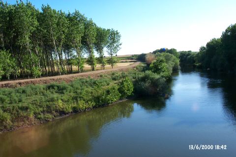 |
|
Type:
|
Mound |
|
Altitude:
|
-20 m |
|
Region:
|
Marmara |
|
Province:
|
Edirne |
|
District:
|
Merkez |
|
Village:
|
Avariz |
|
Investigation Method:
|
Survey |
|
Period:
|
Early Iron Age |
|
|
|
 |
|
| It lies 1 km west of the Avariz Village, approximately 10 km north of the provincial center of Edirne. The mound is located on a natural elevation on the westen bank of the Tuna River where the river forms meander. The river is enclosed by trees to the east, and paddy fields to the west. To the east lie rocky slopes. The mound is approximately 150 m long in the east-west direction, with a height of 4 m. It is being destroyed due to intense cultivation. It was discovered in 1995 during the Survey in the Province of Edirne conducted by B. Erdogu. It is one of the largest Early Bronze Age settlements lying to the north of the Ergene River. Also found is limited number of material dating to the end of the Late Bronze Age, and beginning of the Early Iron Age. |
| Location: |
| Geography and Environment: |
| History: |
| Research and Excavation: |
| Stratigraphy: |
| Small Finds: |
| Remains: |
| Interpretation and Dating: |