|
©The Archaeological Settlements of Turkey - TAY Project
|
|
|
|
|
|
Asarcik Höyük / Ilica |
|
|
For site maps and drawings please click on the picture...  |
For photographs please click on the photo... 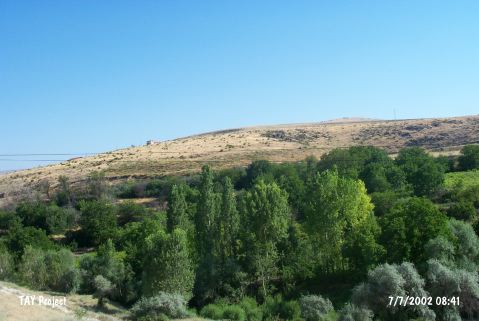 |
|
Type:
|
Mound |
|
Altitude:
|
770 m |
|
Region:
|
Central Anatolia |
|
Province:
|
Ankara |
|
District:
|
Ayas |
|
Village:
|
Ilica |
|
Investigation Method:
|
Excavation |
|
Period:
|
|
|
|
|
 |
|
| It lies adjacent to northeastern end of the Ilica Village, 9.5 km northwest of the Ayas District to the west of Ankara. To the west runs the Güdül-Ankara motorway. Rising on a deposit of settlements over a basalt elevation [Orthmann 1966:plan I] the northern part of the mound faces steep valley of Ilica Suyu. It is located between two streams. The southern part is less steeper compared to the north. Presumably used to meet the water requirements of inhabitants, Ilica Suyu originates from the Mount Kizilcabayõr, flowing through the north of the mound [Kökten 1947:442]. It was discovered by K. Kökten in 1945 [Kökten 1947:442], and excavated under the direction of W. Orthmann on behalf of the German Archaeological Institute in 1963 and 1964. Other than the Asarcik Mound, the cemetery lying to the south of the Ilica Village and dating to a later period was also excavated. Five levels were identified on the mound. Based on the finds, the levels are as follows (in descending order): Level I: Roman-Galat Period; Level II: Hellenistic Period; Level III: Late Phrygian Period (Iron Age); Levels of the extramural residential quarters: second half of the 2nd Millennium BC; Level IV: first half of the 2nd Millennium BC/ Old Hittite Period; Level Va: Transition Period (transition from the First Bronze Age to the 2nd Millennium BC); Level V: First Bronze Age phase III (phases II-III according to the chief excavator). It was re-investigated during the Central Anatolia Survey conducted under the direction of S. Omura in 1994. Sherds collected from the surface are dated to the EBA, MBA, LBA and Iron Age. It takes place in the registered archaeological sites list prepared by Ministry of Culture and Tourism. |
| Location: It lies northeast of the Ilica Village; 9;5 km from northwest of the Ayas District; west of the Ankara Province. The Güdül - Ankara motorway is on the west of the village. |
| Geography and Environment: The northern part of the mound located on a basalt hill elevated by the accumulation of settlements [Orthmann 1966:plan I] faces the steep and abrupt valley of the Ilica Suyu. Asarcik Höyük is somewhat different than the other settlements since it is located between the two streams. The southern part is not as steep as the northern part. The stream of Ilica Suyu on the north; originating from the Kizilcabayir Dagi; presumably supplied water to the inhabitants [Kökten 1947:442]. |
| History: |
| Research and Excavation: |
| Stratigraphy: |
| Small Finds: |
| Remains: |
| Interpretation and Dating: |