|
©The Archaeological Settlements of Turkey - TAY Project
|
|
|
|
|
|
Altintepe |
|
|
For site maps and drawings please click on the picture...  |
For photographs please click on the photo... 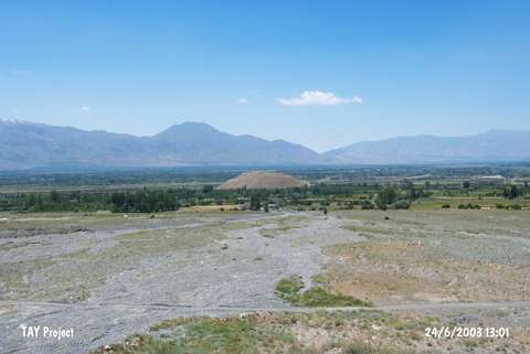 |
|
Type:
|
Mound |
|
Altitude:
|
1290 m |
|
Region:
|
Eastern Anatolia |
|
Province:
|
Erzincan |
|
District:
|
Üzümlü |
|
Village:
|
Merkez |
|
Investigation Method:
|
Excavation |
|
Period:
|
Middle Iron Age |
|
|
|
 |
|
| Location: It lies to the immediate north of the Erzurum-Erzincan motorway, 20 km east of Erzincan. |
| Geography and Environment: Lying on the northern edge of the very fertile Erzincan Plain, Altintepe also commands the renown trade road running from East Anatolia to Central Anatolia. The oval-planned hill on which the fortress of Altintepe rises is 60 m high above the plain. It is 1290 m high. |
| History: |
| Research and Excavation: Altintepe was first introduced with the discovery of a rich prince's tomb in 1938. Excavations were initiated in 1959 under the direction of T. Özgüç. And, they were resumed in 2003 by a team under the direction of M. Karaosmanoglu after a period of 34 years, which have been continuing since then. |
| Stratigraphy: The excavations at Altintepe yielded remains from the First Bronze Age, Iron Age and Middle Age. |
| Small Finds: Architecture: The Temple: The excavations yielded an Urartian temple in full plan. Measuring 13,80 m on each side, it has a square plan. It is located in a courtyard which has an inner dimension of 27x27 m. The cell with four very thick walls in the shape of a square tower was built near the rear wall. This is a common feature of all Urartian temples. It provides space for a wide courtyard to allow crowded people in front of the cell. The courtyard is enclosed by galleries on four sides. The depth of frontal and rear galleries is less than the lateral ones. The walls of the courtyard are 2 m thick. They have stone foundations and mudbrick walls. The roof of the galleries built with wood and mud are supported by twenty wooden poles, standing on very well dressed stone bases. Large parts of these wooden poles were found on the floor of the temple's courtyard on the side of the cell. The stone bases measure 0,75 cm in diameter, and 0,20 cm in height. The distance of stone bases to the wall on the temple side is 7,20 m, and 3,50, 3,00 and 2,50 m on sides and the rear, respectively. There is a water channel in the open courtyard. With a thickness of 4,35 m, the temple walls are covered with three courses of cutstones dressed using the Urartian technique. Also, there is a two flight of steps in front of the 1,15 m wide gate and between the two doorjamb blocks. A 3,8 m long, and 1,50 m wide corridor allows access to the cell, which measures 5,20 m on each side with a square plan. The courtyard where the temple lies was measured in 2006, and it was found that its dimensions are 27.20 x 30 m; a rectangular plan, and not a square plan; 27x27 m as it was measured previously. Wall thicknesses for the walls encompassing the courtyard are not a homogenous 2 m all around, but it differs; 2.3 m in the east and north, 2.07 m in the west, 1.65 m in the south, where the walls are supported by risalites. Column pedestals, that compose the portico along with courtyard wall, also have different diameters; these differ between 68 cm and 72 cm. The distance of stone pedestals from temple façade is not 7.2 m, it measures 7.33 m from risalite walls, 7.83 m from the walls that bear the doors. The sidal distances are 3.15 m in the east, 2.75 - 2.90 m in the north, and 3.7 m in the west [Karaosmanoglu et al. 2008:498]. Altintepe Urartu Temple is particularly important among the 9 temples of Urartu Architecture in the region with the same plan, as the sole example encompassed by porticoes. The courtyard wall façade, that bears the gate was emphasized through 5 supporting risalites. 20 column pedestals encompassing the walls inside the courtyard, with their bottoms buried in the ground support wooden beams of the portico. There was a large structure approximately 9 m from the temple's front courtyard wall, at 2 m height and there were two rooms at temple floor level which was part of this structure [Karaosmanoglu et al. 2008:499]. The palace unearthed during the initial 2007 excavations was named "Western Rooms" and enumerated. The sewage, which was not identified during the cleaning of the rooms, was revealed. The end of the sewage was found at the southwest side of the kitchen in Apadana. Apparently the sewage was preplanned before the foundation of the fortress during Urartu period, and built underneath its floor, then the upper structures were constructed on this substructure [Karaosmanoglu 2009:120-123]. The 2008 campaign focused primarily on the identification of west room walls. It was found that the east wall of room #6 extended towards the kitchen structure north of Apadana in the first phase. Rooms 7 and 8 were added on the east wall extension. The sewerage found in 2007 consists of masonry below the surface. A first phase single course of masonry was unearthed immediately above [Karaosmanoglu 2010:18-19]. Open-air Shrine: There are Urartian chamber graves and an open-air shrine on a long terrace approximately 40 m above the plain level on the southeast slopes of Altintepe. The open-air shrine is situated on the northeast end of the long terrace bearing the grave, adjacent to grave #1 [Karaosmanoglu 2010:23]. The 2014 studies were carried out in the northeast section of the area. About 1 m deep part of the new trench with a dimension of 4.00x4.00 m consists of stone and mud brick fill that were eroded from the slope. At a depth of -1.30 m, a layer of ash with a thickness of 0.30 m was found. This layer, which has no connection with any level, has an appearance of slope flow [Karaosmanoglu et al. 2016:135]. The 2015 excavation studies were carried out in the small room in the west section of the area. Beneath the dense rubble fill that flowed from the slope, traces of a basket made out of thatch or mat were found on the floor of the room. Remains of strings belonging to the basket or mat sack were also found. A basin (?) placed into the bench was exposed in the east of the west wall. This basin is encircled with plastered stone and mud brick. The pit in front of the basin is also noteworthy. The corner of the basin, which is in alignment with the pit, was deliberately left open in the shape of a gutter. It is believed that this opening was used for drainage. In the south of the west wall, a hearth encircled with stone and mud brick was found. After cleaning the mud brick rubble around the hearth, it was seen that it is in an angled "U" shape. A panel with coarse pebbles, the upper section of which is burnished, was found on top of the hearth. This panel measures 0.53x0.42 m. The panel was found as being collapsed into the hearth. Its short sides are in straight profile, while its long sides are flat. A hole with a diameter of 0.20 m and a depth of 0.10m from the circular-like floor was found just to south of the hearth. Two stones were placed into this hole, which is probably used for wooden posts. It is understood that the wall which was exposed in 2014 and functions as a partition was added later. Given that there is no wall, it can be suggested that this space, which contains a bench extending along the northwest wall, a basin and a hearth, was used as a workshop [Karaosmanoglu et al. 2017:238-239]. Apadana: Apadana excavations were also initiated during 2004 campaign. The structure which is very uncommon compared to the ones in other Urartu centers in terms of its architecture, has particularly a different stone masonry and technique on the east façade that faces the courtyard, suggesting a two level structure in Apadana [Karaosmanoglu at el. 2006:184]. But, during 2005 excavations at first level, it was found, that there was a large structure with unidentified plan, which is contemporary of the Urartu period temple; then a structure at building level 2, containing four walls decorated with depictions, that rests over the temple wall, previously named Apadana in T. Özgüç's publications, was identified as a Byzantine period chapel [Karaosmanoglu et al. 2007:262]. The first level building's plan could be drawn after the three walls of the first level building was unearthed during 2006 excavations at Apadana. There is a high chance the first level building may be a two nave Apadana [Karaosmanoglu et al. 2008:499-501]. Based on the excavations in front of the temple courtyard gate of the first level building, the two rooms unearthed at temple level, of which one possibly was the kitchen, it is a large size structure that measures approximately 6x15.85 m. When this place was entirely unearthed in 2008 two furnaces, a hearth, four pithoi were revealed along with two entirely burnt wooden beams buried into the floor of adobe soil uncovered during previous campaigns, each 15 cm in diameter and 2.40 m apart in the west section. The thin beams were placed approximately 10-15 cm inside the soil and contained no pedestals. Therefore believed to have no function of roof supporting [Karaosmanoglu 2010:20-21]. As a result of excavations the forms of the structures placed around the first phase Apadana were identified. There is a room measuring 6x5 m north of the structure, a kitchen adjacent to and west of it, a large structure accessed by a climbing road in the west and a second structure immediately south of it [Karaosmanoglu 2010:22]. During the excavations carried out in 2009 it was observed that the West and North walls of Early Apadana are expanded by approximately 6 m each and the 2 m level difference in both sides is filled with the ruins of the demolished buildings which was once standing here for the purpose of erecting the wider Apadana. The Southeast Wall of Early Apadana is completely excavated. This wall is inside the wider Apadana wall and continues through the South Wall of Early Apadana with a bulge in the middle. It is definite that the entrance point of Early Apadana and wider Apadana are the same [Karaosmanoglu et al. 2011: 165]. During the 2010 studies; it was found out that Apadana was accessible with a wooden ladder since no evidence of an architectural element belonging to a ladder was found in the front room of the door at the lower elevation. The entrance door was used and in both periodsand it underwent several modifications. It has been observed that it the room; which measures 3.17x4 m; belonging to the first phase has been reused in the second phase as well. It was partly narrowed down and used for the same function. 3 pithoi which were buried to the ground were exposed outside the west wall of Byzantine tower. The stone foundation of the wall which is located parallel and has the same thickness with the west wall of the storage room of Apadana belonging to First period has been unearthed. The foundation extends towards the underneath of the enlarged west wall of Apadana. It is about 2.65 m wide. Small trenches were opened at the bottom of the column bases inside Apadana. It was discovered that the column bases which their diameters range from 105 cm to 122 cm belong to the second phase and they were used only once [Karaosmanoglu et al. 2012:305-306]. It was observed that the wall with a width of 1.75 m, which was discovered on the west outside corner of Apadana during the excavations carried out under the leadership of T. Özgüç, continues from beneath the enlarged Apadana wall and extends towards the south. The wall was damaged after reaching 5.90 m [Karaosmanoglu et al. 2013:137]. In 2013, the studies carried out in the south of Apadana. In the room that has a compressed clay floor, pits dug into the floor were found. It is believed that these pits functioned as workshop. Under the floor of this room, there is a fill with a thickness of about 1.50 m. Wall foundations belonging to the structures added to Enlarged Apadana were exposed under this fill [Karaosmanoglu et al. 2015:141]. The 2014 studies were carried out in order to understand the settlement structure in the south of the Apadana and to reveal the last section of the Middle Age city wall. At a depth of -0.40 m, a course of stone with a length of 2.20 m and a width of 0.50 m was exposed. It is thought that this row of stone is related to the stones belonging to the Late Middle Age that were exposed in the previous season [Karaosmanoglu et al. 2016:133]. The 2015 studies were aimed to see the fire level, which was partially exposed in the previous season, on a wider scale and therefore a new trench was opened. At a depth of -1.20 m, mud brick debris was found together with rubble stones. This space is surrounded by the Byzantine city wall in the south, the expanded Apadana wall in the north, the second phase of Urartian wall in the west, and the boundary of the trench in the east. The north corner of the space is named as A, the east corner B, the south corner C and the west corner D. In the Square A, an installation with a dimension of 1.60x1.60 m, surrounded with wooden logs and the center of which is filled with crushed stones, was found on the platform located at a depth of -2.55 m from the Apadana floor. Its function is not yet determined. In Square B, an installation showing similar characteristics and size with the one found in the Square A was also exposed. Although the floor of this installation shows similarities to siloi, it does not meet the definition of siloi in terms of other architectural features. Therefore, some other function should be considered. There are some examples showing the use of flat stone or wood as a transition element between stone foundations and mud brick walls in the Urartian architecture. In Area C, an installation in oval shape, which is thought to be an oven, was exposed. Its sides are covered with clay and its floor is covered with crushed stones, thin pebbles and a baked clay panel with coarse inclusion, respectively. The profiled and sooted mud brick fragments indicate that the oven have once had a dome. The eastern part of the oven is bordered with a stone, one side of which is worked. The mouth of the oven is probably located over this stone. Similar ovens are known from Middle Bronze Age Norsun Tepe in the Eastern Anatolia, and Seyitömer Höyük in the Western Anatolia. The radiocarbon samples taken from the oven show that it is dated to the first quarter of the 2nd millenium BC [Karaosmanoglu et al. 2017:236-237]. The Pool: It is possible that the courtyard with pebbled floor, located between the west inner city wall and the rooms numbered 5 and 6 in the west of the temple complex, belongs to the pool. The studies carried out in the saltpans in the region show that the salt ponds bear the same characteristics with this pool. Therefore, it is possible to say that this tradition continues in the region since Urartian Period [Karaosmanoglu et al. 2013:138]. The Studies Outside the North City Wall: In 2011, the studies carried out in the area in the west of the depot located outside of the north city wall. Remains of wooden beams, which were discovered during the 2010 campaign, were completely exposed. These remains extending in the southwest direction give a clue about the wooden roofing of the Urartian buildings. [Karaosmanoglu et al. 2013:138]. The Studies Outside the East Inner City Wall: The fill composed of mudbrick wall debris and remains of foundation stones belonging to the east inner city wall yielded a stone hearth located beneath the large and small stones. This stone hearth measures 0.47 m in diameter and it has a hollow with a diameter of 0.21 m and a depth of 9 cm on its center. The outer wall of the tower with a length of 5.30 m, which is located between the entrance of Middle Age castle and the entrance belonging to Urartian Period, was entirely exposed. The towers located both sides of the entrance were also cleaned and unearthed [Karaosmanoglu et al. 2013:139]. The Studies Carried Out on the East Outer City Wall: During the studies conducted in the west of the church, the foundation stones with a length of about 40 m belonging to the Urartian city wall were discovered. The city wall, three rows of which were preserved, was built with neatly worked large stones [Karaosmanoglu et al. 2013:139]. In 2013, the studies were carried out in the northeast terrace in order to find the continuation of outer city walls and the entrance of the tower located on the outer city wall. To the east of the well-built wall that possibly belonged to Urartian outer city wall, the wall extensions built with smaller crushed rocks were seen. These walls were built without mortar. A jar (urn) and a bowl, which were completely fragmented, were found in front of the city walls on the eastern slope [Karaosmanoglu et al. 2015:140]. The 2014 studies were carried out in order to determine the extensions of the Urartian mortarless walls and Medieval walls, which were exposed in the eastern slope in 2013, and their position in the chronological process of the castle. It is revealed that this wall, which was thought to be the Medieval outer city wall, belongs to a tower. At the elevation of -2.40, the extension of mortared city wall was exposed in Trench D that measures 6x5 m. As a result of these studies, the total length of the mortared city wall reached 15.60 m in the north-south direction. In Trench E, the wall, 6.60 m of which was exposed, is probably one of the terrace walls between the citadel wall and outer city wall of the Urartian castle. A layer of solid clay with a wall thickness of 0.72 m and two tandoori under it were uncovered in the southern section of the terrace wall. The tandoor is strengthened with mud brick blocks. One of the tandoor was opened and a clay sample was taken. No in situ finds were found [Karaosmanoglu et al. 2016:131-132]. In 2015, the studies were carried out in Trench F that was opened in the previous seasons. A new trench named as G was opened in the northeast of Trench F. Trench K was opened in order to understand whether the remains of mud brick found in the newly opened Trench H was wreckage or a wall mounting. Although it is aimed to reveal the Urartian outer city wall and foundation stones in this area, a simple earth grave that is bordered with a thin wood was found. It is determined that this grave is dated to the Late Christian Period [Karaosmanoglu et al. 2017:234-235]. Outside of the West Inner City Wall and the West Water Gate: In 2012, it was revealed that the walls vertically extend towards the west inner city wall, don't belong any structure. It is believed that these walls were built to support the city wall. An entrance path, which ends with a step, was exposed outside the area that is cut by Middle Age city wall. Between the entrance and exit steps, a door with a dimension of 2.75x4.70 m is located. This small door belongs to the Urartian Inner Fortress and it is called West Water Gate. It is believed that the door was used as a passage to the water source on the western skirts of Altintepe [Karaosmanoglu et al. 2015:139]. The West Outer City Walls: During the studies conducted in 2013, remains belonging to a door were found in the terrace in which the west outer city walls are located. The remnants consist of rows of stone facing each other. These stones extend in the north-south direction and the distance between them is 5 m [Karaosmanoglu et al. 2015:140]. Trench 1 on the top of the Church: The trench measuring 2.50x2.50 m yielded a part of the city wall descending in the south-north direction. It was observed that this city wall continues towards the northwest with an addition of a tower. In this area, 5 graves belonging to the Middle Age were found [Karaosmanoglu et al. 2013:139]. Depot: While its function is not clear, a huge depot-like structure is encountered during the excavations in the East of the Temple Complex under the floor which is paved with flat stones and constructed with large, high-quality walls from the Urartian Period of the fort. After a severe earthquake destroyed the fort this stone structure has lost its function and filled with clay soil up to approximately 1.50 m and transformed into a new depot building in which pithoses are buried up to shoulders [Karaosmanoglu et al. 2011:167]. In 2010, the northern section of the storage was excavated. The storage is in rectangular plan and it measures 16.15x27 m. Based on the bases found, it has been suggested that the roof of the storage were carried with wooden posts founded on stone pedestals with two rows. The interior sections of pithoi were burnt and the reason for that could be the fire which occurred at the end of Urartian Period. The traces of fire can be also seen at the other structures of the castle [Karaosmanoglu et al. 2012:304-305]. Stone Building: This building was exposed during the first excavation seasons. However, it has not been shown in the plans. Therefore, it was investigated in 2013. The building, built underground, is located in the middle section in the northwest of the hill. This area is covered with mudbrick rubble of the inner city wall. Under this rubble, wall foundations extending in the east-west direction were exposed [Karaosmanoglu et al. 2015:137-138]. The studies were conducted in the southwest of the building with the aim of clearing out rubble inside the building in 2014. Remains of a stone foundation belonging to a structure that is later than the Stone Building were found. The remains sat on the southwest corner and measure 7.30 in length and 1.40 m in width. After these remains were removed, the front face of the long south wall of the Stone Building was exposed. A wooden beam fragment was found at a depth of -5.60 m from the slope level [Karaosmanoglu et al. 2016:130]. Pottery: An in situ pithos was unearthed and the section known as the kitchen in first level Apadana during 2007 excavations. The dirt deposit around it contained a sherd on which an animal head was depicted in silhouette style, along with some geometrical decorations, and other sherds with chisel decorations [Karaosmanoglu 2009:122-123]. Urartian pithoi fragments with hieroglyphic inscriptions and embossed crescent motifs, and a sherd with chiseled animal figure were found inside the deposit soil northwest and south of the first phase building of Apadana during 2008 excavations [Karaosmanoglu 2010:21-22]. Many sherds were unearthed at the open-air shrine [Karaosmanoglu 2010:24]. 3 pithoses buried below the ground level of a room are unearthed during the excavations carried out in 2009 in Apadana. The dimensions of the room could not be clearly measured. The jugs are lined up and buried under the ground level up to their shoulders (similar to other Urartian Fortresses); this suggests the existence of a depot building associated with Early Apadana [Karaosmanoglu et al. 2011: 165]. Pithoses are also encountered during the excavations carried out in the depot building in the East of the Temple Complex. A layer of burnt oil found inside the pithos evidence that they contained oil and underwent a severe fire. Some of the pithoses are re-used after coated with a white, natural material. Some has hieroglyphics carved on some of them at a later time [Karaosmanoglu et al. 2011.167]. During the 2010 studies conducted outside of the north city wall, Late IA potsherds with painted bands and a monochrome potsherd which imitates metal bowls were recovered in Area KSD3. In Area KDS 4, a few painted potsherds belonging to Late IA were found as well [Karaosmanoglu et al. 2012:307]. In the west of the trench opened in the west corner of the depot, a scattered pithos belonging to the Urartian Period was found. Potsherds belonging to a pithos, which was heavily damaged, were encountered at the bottom of the East Inner City Wall in the west of the stone hearth. The sherds bear 7-8 repairing holes [Karaosmanoglu et al. 2013:138-139]. During the 2014 studies carried out in the northeast of the Open-air Shrine, bright black burnished potsherds with double knob indicating pre-Urartian period were found at the elevation of -3.20 m [Karaosmanoglu et al. 2016:135]. The 2015 excavations yielded potsherds recovered from various areas. Urartian pithos sherds were found in the mudbrick rubble during the excavations carried out in the south of Apadana. Most of the potsherds, found around the oven in Area C of Apadana, are bright black burnished and have incised decoration. The potsherds showing BA characteristics indicate the earlier period of Altintepe. The basin, exposed in the area in the east of the open-air shrine, contains an unbaked clay bowl with a diameter of 0.20 m and a height of 0.10 m. The potsherds recovered from this area are also bright black burnished and have incised decoration like the ones found in the south of Apadana [Karaosmanoglu et al. 2017:236-239]. Graves: Three graves were found on the southeastern ridges of Altintepe, built 40 m high above the plain level. They are located almost at the same level within an area of 40 m. The first grave was noticed by the villagers who removed the stones, exposed as a result of land sliding and erosion in 1938, and the grave gifts inside it were mostly looted. Interestingly the grave chamber was not completely damaged, some gifts being untouched. A major of the gifts found by the villagers was brought to the Archeological Museum of Ankara within the same year. None of the golden, silver, wooden, precious stone and ivory items were retrieved. It appears that particularly small items in iron, bronze, and terracotta were damaged when the grave was first disturbed. The second grave was accidentally found by the road workers in 1956, who disturbed the grave by removing one of the lidstones on the roof, resulting in destruction or loss of an important part of the grave gifts. The third grave was revealed untouched by the excavation team in 1959. The graves yielded pottery, bronze belt, two bronze leads, a bronze cauldron including horse figurines and a set horse harness, wooden furniture fragments, and skeleton fragments of a child in the first grave. Built with cutstones, the graves included several golden, silver, bronze, ivory, iron, terracotta, stone and ceramic goods, silver and bronze coated furniture fragments, bronze belts, various wooden furnitures, bronze cauldrons, and a chariot seemingly belonging to a prince. Huge tripod cauldrons in bronze with bulls' head attachments recovered from these graves are very interesting. Next to the graves is an open-air sanctuary enclosed by stone walls on four sides. During the studies conducted in the East Outer city wall in 2011, a grave was found. The grave was surrounded by a wooden beam with a height of 0.20 m and a width of 0.10 m [Karaosmanoglu et al. 2013:139]. During the 2014 studies, the debris inside the grave no.1 was removed. The grave was reached from the entrance door on the south wall and then the room in front of the entrance was cleaned. The lever/lock setup of the door on the left of the entrance was removed from its original place by illicit diggers and put in front of the entrance. The setup belonging to the door on the right of the entrance were found in situ. There are 4 protrusions with a dimension of 0.12-0.13 m and 3 recesses with a dimension of 0.06-0.07 m on the upper sections of these setups made of andesite block. There is also a slot, measuring 0.15 in width and 0.05 m in depth, for the door stone. It is believed that the setup works with the help of a lever and two sticks. The grave no.3, which is located on the same terrace about 25 m southwest of the grave no.1, was cleaned. The grave was exposed during the excavations led by T. Özgüç and it has an important place in the Urartian grave architecture. The revetment wall built on the slope behind the grave exploded due to natural factors and it collapsed into the room containing sarcophagi. The studies were initiated at the entrance and in the room in front of the entrance. The stones were carried via hoist from the grave. After cleaning the main entrance door, it was seen that the threshold stone was in situ. The burial room was dug until the floor unearthed and the room containing sarcophagi was cleaned. It was seen that the sarcophagi, which are the only examples made out of stone during the Urartian Period, was not damaged like the ones found in the first excavation campaign [Karaosmanoglu et al. 2016:136-138]. Human Remains: The grave, discovered during the studies carried out in the East Outer city Wall in 2011, contains a skeleton. The skeleton lies on his / her back and faces the northwest. It is suggested that this skeleton belongs to an adult [Karaosmanoglu et al. 2013:139]. In 2014, a high density of ash, animal bones, obsidian pieces and oven fragments were found in the space (named Space no.1) in the northeast of the Open-Air Shrine. The space measures 1.70 in width. The finds indicate that it might have been related to mortuary practices or cremation process [Karaosmanoglu et al. 2016:135-136]. Small Finds: Many offerings were found in the cell of Altintepe including six spearheads in bronze, and many in iron, four scepters or mace heads, two in bronze and two in iron, iron arrowheads, three red washed, burnished vases with high stands and inlaid wooden plaques, which were placed in front of the sculpture base. The technique and style of votive items represent Urartian art. Also found are ivory works in one of the galleries of the Urartian temple and the Urartian graves. Among the finds are statues of three griffin-headed men, two intact and one damaged statues of lions, engraved relief of a deer, two human faces in inlaid ivory technique, four palmettes, three pieces of winged sun disks, a fortress model, several fragments and heads of furnitures, an ivory statue with only two crossed hands and the left arm. The excavations at Altintepe yielded a palace, temple, wall drawings, graves, storages and ivory works, which were all published. Evaluations reveal that the fortress have been disturbed and is still being disturbed by many illicit diggings. During 2006 excavations a metal bowl was found, similar to Urartu period ceramic bowls. It had a large mouth and a rim that extends outwards, which had a diameter of 18 cm, its neck was fluted. A ceramic seal was unearthed at the same spot, the same year. There is a cattle depiction with its legs crossed and a crescent relief on its back in the center of the seal, inside a circle with indentations on the edges, placed on the outside surface of a flat bowl. The ceramic specimen consists of four sherds and has a reddish color [Karaosmanoglu et al. 2008:502-503]. A bronze bracelet, the fragment of a broken stone vessel, wooden pieces and small obsidian flakes were unearthed at the open-air shrine during 2008 excavations [Karaosmanoglu 2010:24-25]. The stone in the shape of rectangular parallelepiped was found inside the city wall in the north of the Trench 1 on the top of the church. There is an eyelet on its burnished flat surface and the traces of rubbing suggest that it was used as whetstone. The stone tool that was found in the same area has an eyelet on its handle as well [Karaosmanoglu et al. 2013:140]. |
| Remains: |
| Interpretation and Dating: Being located on the northern section of the Erzincan Plain, Altintepe commands the renown trade road running from East Anatolia through Central Anatolia. It is undoubtedly one of the important centers on the borders of the northwest extension area of the Urartians. Altintepe is one of the sites which played a significant role in elucidating the history and art of the Urartian Kingdom. |