|
©The Archaeological Settlements of Turkey - TAY Project
|
|
|
|
|
|
Akalan Kalesi |
|
|
For site maps and drawings please click on the picture...  |
For photographs please click on the photo... 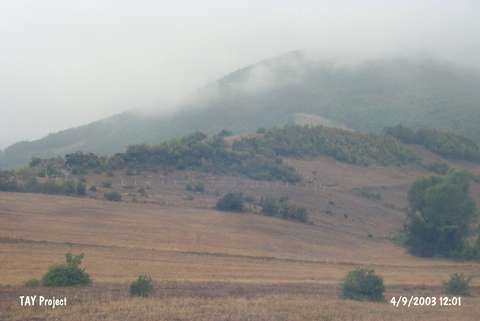 |
|
Type:
|
Mound |
|
Altitude:
|
420 m |
|
Region:
|
Black Sea |
|
Province:
|
Samsun |
|
District:
|
Merkez |
|
Village:
|
Çatmaoluk |
|
Investigation Method:
|
Excavation |
|
Period:
|
Late Iron Age |
|
|
|
 |
|
| Location: It is a fortified settlement which lies 2 km to the south of the Yeniköy Quarter in the Çatmaoluk Village, 18 km to the southwest of Samsun. |
| Geography and Environment: It was founded on the steep slope of a high plateau. To the south, north, and west, it is delimited by the Karadere Brook, a tributary of the Kürtün Stream spilling into the Black Sea, and its tributaries. |
| History: |
| Research and Excavation: An excavation was conducted in the fortress in 1906 by Th. Macridy-Bey. Later on, it was surveyed by H.H. von der Osten, U.B. Alkim, M. Özsait and S. Dönmez, respectively. A recent survey was conducted by a team consisting of Ö. Bilgi, S. Atasoy, F. Gökçe and S. Dönmez in 2001. It takes place in the registered archaeological sites list prepared by Ministry of Culture and Tourism. |
| Stratigraphy: The excavations revealed that it was a significant Iron Age settlement. Sherds from the EBA were uncovered in the fortress and its vicinity during the survey by Alkim and Özsait. It indicates that the occupation in the site goes back to the 3rd Millennium BC. |
| Small Finds: Architecture: The citadel is enclosed by a defence system, which was adapted to the topography as some being obscured by soil with an approximate lenght of 1 km. The bedrock served as a natural foundation for the walls at some sections. Preserved up to a mean height of 4.50-5.00 m, the walls have an inclination of 55-60 degrees on the northeast while it reaches up to a steepness of 80 degrees toward the west and south. It was built with cyclopic and rough stones using a massive technique. The interstices were filled with rubble. The wall thickness is uncertain. It seems that it had a tall wall body made of brick. The fortress is known to have two entrances. The first and larger one to the southeast is flanked by two tower-like large walls. The second smaller entrance lies to the northeast of the fortress. The 7-8 m elevation in the middle of the fortress is considered as a mound [Alkim 1973]. The citadel excavations yielded a rectangular building and a stone footpath to the southernmost. Also traces of a devastating fire were detected, but no information is available on the ground plan of the structures. The surveys in the citadel and around it yielded sherds, of which majority dating back to the Late Iron Age, and terracotta coating plates, roof tiles and architectural elements consisting of acroterion fragments. Pottery: They are mainly divided into two groups. The first group consists of the painted local ware comparable with the Alisar IV observed in Central Anatolia, and it accounts for the majority in quantity. Forms of kraters, bowls, and jugs with trefoil and round mouths are available [Cummer 1976:pl.6-8]. The dark colored decorations (dark red, brown) on a buff-slip or a white background include various band decorations, bands within panels, dotted hook motifs, crossed triangles, concentric circles and animal figures [Makridy 1907:pic.17; Cummer 1976:pl. 6-8]. The second groups, seemingly imported, is composed of the pottery of the Aegean origin, also called East Greek. They include fragments of oinochoe decorated in wild goat style [Cummer 1976:pl. 7/53-57]. Statue/Relief: The terracotta architectural wall coating plates, roof tiles and group of fragments forming the acroterion are the most significant and interesting finds recovered at Akalan. The motifs in relief and matt-paint on the plates were made using tile red, dark brown, brownish black, greyish black and yellowish brown on beige [Akerström 1966:121-133]. The cover plates are classified in two groups in terms of functionality; ones with a waterspout hole and the wallboards. Compositions of lions and lion-panther figures facing one another are observed on the specimens, which seem to have been lying on the fascia at the edges of the roof based on the waterspout holes. The wallboards are also richly decorated. Among them are compositions with various figures as well as plant patterns including braiding band and braiding band-rosette motifs with lotus-palmette frieze, and geometrical patterns including meander, lozenge pattern, rectangular and envelope motifs. The roof tiles are plain. The acroterion fragments are decorated with a fish-scale motif made by paint. Also noteworthy are two ears and body fragments of a large size gryphon, probably used as an acroterion [Cummer 1976: pl.9/58-61]. |
| Remains: |
| Interpretation and Dating: Based on the pottery finds, the fortress of Akalan is dated to the early or mid 6th century BC [Cummer 1976:31; Dönmez 2004:71]. Researchers like A. Akerström, K. Bittel, and S. Atasoy suggested that Akalan was a colonial city founded by Phocaeans and Miletians who arrived in Amisos (Samsun) based on the Greek influence on the potsherds in the bezoar goat style and the architectural wall coating plates [Akerström 1966:132; Bittel 1950:88,98; Atasoy 1997:39]. On the other hand, W.W. Cummer, and recently S. Dönmez, pointed out the close relationship of the available data with the Central Anatolia, and suggested that Akalan might have been founded by the local people who arrived in the region from Central Anatolia during the early 6th century (Late Iron Age) [Cummer 1976:35; Dönmez 2004:71]. In 1907, Macridy Bey proposed identification of Akalan with the ancient city of Pteria [Macridy 1907:174-175]. This proposal was reawaken by S. Dönmez in 2004 based on new finds [Dönmez 2004:74-77]. Any systematic excavation to be conducted in the site will bring light to the issues related with the Late Iron Age as well as to the ancient name of the settlement. |