|
©The Archaeological Settlements of Turkey - TAY Project
|
|
|
|
|
|
Damlali |
|
|
For site maps and drawings please click on the picture...  |
For photographs please click on the photo... 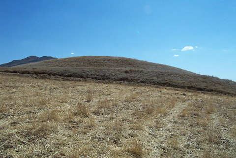 |
|
Type:
|
Upland Settlement |
|
Altitude:
|
m |
|
Region:
|
Mediterranean |
|
Province:
|
Adana |
|
District:
|
Tufanbeyli |
|
Village:
|
Damlali |
|
Investigation Method:
|
Survey |
|
Period:
|
|
|
|
|
 |
|
| It stands on a small natural rock on the road running from Tufanbeyli to Doganli; 2 km west of Tufanbeyli; northeast of Adana Province. It measures 5 m in height and 70 m in diameter. Sherds of plain ware; suspected mottled ware; coarse kitchen ware were collected from the surface. They are dated to the EBA by G.H. Brown. The site was reinvestigated by K.S. Girginer in 2002 and named as Küçük Sari Faki Höyük. A silex flake was found during the survey. The survey material also includes sherds that can be dated to the EBA. Some of these sherds belong to red polished and burnished forms. In the same survey; sherds belonging to more coarse bowls and pots that might be kitchen pots were also found. Sherds dating to the first half of the first millennium BC and Roman period were also encountered. |
| Location: |
| Geography and Environment: |
| History: |
| Research and Excavation: |
| Stratigraphy: |
| Small Finds: |
| Remains: |
| Interpretation and Dating: |