|
©The Archaeological Settlements of Turkey - TAY Project
|
|
|
|
|
|
Çukurköprü |
|
|
For site maps and drawings please click on the picture...  |
For photographs please click on the photo... 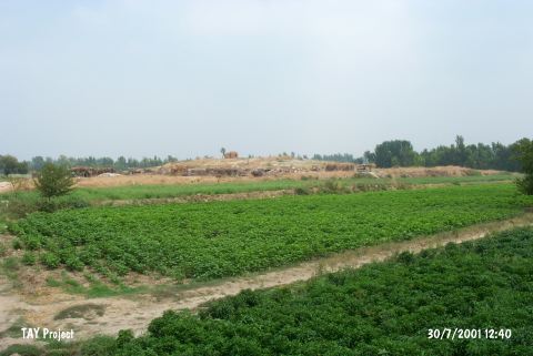 |
|
Type:
|
Mound |
|
Altitude:
|
80 m |
|
Region:
|
Mediterranean |
|
Province:
|
Osmaniye |
|
District:
|
Kadirli |
|
Village:
|
Çukurköprü |
|
Investigation Method:
|
Survey |
|
Period:
|
|
|
|
|
 |
|
| The broad; 3-4 m high mound lies nearby Anavarza junction; south of Kozan-Kadirli motorway and Çukurköprü Village; west of Kadirli Dİstrict; northeast of Adana Province. It was slightly damaged by the village road. Ceramics; recovered during the 1951 Survey conducted by M.V. Seton-Williams; are of Coba ware. Except for the EBA; the mound was occupied from the LNA until the Roman Period. |
| Location: lies nearby Anavarza junction; south of Kozan-Kadirli motorway and Çukurköprü Village; west of Kadirli District; northeast of Adana Province. |
| Geography and Environment: Approximately 30-40 m of this low lying; 3-4 m high mound has been destroyed by highway construction. There are no water sources or modern towns near the site. There must have been a nearby water source when the mound was inhabited. |
| History: |
| Research and Excavation: |
| Stratigraphy: |
| Small Finds: |
| Remains: |
| Interpretation and Dating: |