|
©The Archaeological Settlements of Turkey - TAY Project
|
|
|
|
|
|
Çukurköprü |
|
|
For site maps and drawings please click on the picture...  |
For photographs please click on the photo... 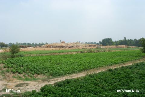 |
|
Type:
|
Mound |
|
Altitude:
|
80 m |
|
Region:
|
Mediterranean |
|
Province:
|
Osmaniye |
|
District:
|
Kadirli |
|
Village:
|
Çukurköprü |
|
Investigation Method:
|
Survey |
|
Period:
|
Ceramic |
|
|
|
 |
|
| Location: lies nearby Anavarza junction; south of Kozan-Kadirli motorway and Çukurköprü Village; west of Kadirli District; northeast of Adana Province. |
| Geography and Environment: Approximately 30-40 m of this low lying; 3-4 m high mound has been destroyed by highway construction. There are no water sources or modern towns near the site. There must have been a nearby water source when the mound was inhabited. |
| History: |
| Research and Excavation: The site was discovered by M.V.Seton-Williams during the surface survey he conducted in Cilicia in 1951 [Seton-Williams 1954:130;153]. |
| Stratigraphy: Seton-Williams reports that he collected Late Neolithic-Early Chalcolithic; Middle and Late Bronze Age and Roman sherds at the site. Like many sites in the Çukurova Plain; it is difficult to be precise about the earliest levels. The finds were compared to the Mersin Yumuktepe finds. |
| Small Finds: Pottery: The ceramics include some dark burnished pre-Halaf pottery. It has been suggested that these are examples of Dark Burnished Ware. No other information on the ceramics has been provided. |
| Remains: |
| Interpretation and Dating: The ceramic finds have been compared with Mersin Yumuktepe XXVI-XXIV. In ASPRO; they are placed into the sixth phase and are dated between 7;600 and 7;000 BP [Hours et al. 1994:105]. This site is another Neolithic Çukurova site that needs to be viewed with skepticism. |