|
©The Archaeological Settlements of Turkey - TAY Project
|
|
|
|
|
|
Hashöyük |
|
|
For site maps and drawings please click on the picture...  |
For photographs please click on the photo... 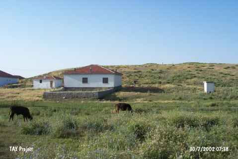 |
|
Type:
|
Mound |
|
Altitude:
|
1230 m |
|
Region:
|
Central Anatolia |
|
Province:
|
Kirsehir |
|
District:
|
Merkez |
|
Village:
|
Hashöyük |
|
Investigation Method:
|
Excavation |
|
Period:
|
|
|
|
|
 |
|
| It lies next to the village of same name, 35 km east of the provincial center of Kirsehir. It is a flat hill measuring 400 m in lenght, 300 m in width, and ca. 8-10 m in height. It was first introduced by H.H. von der Osten, and the first excavation was conducted in 1931 by L. Delaporte. A second campaign was initiated in 1943 under the direction of H. Çambel on behalf of the Turkish History Institution in order to confirm the outcomes of the first excavation. The excavation covered an area of ca. 80x5-10 m. A depth of 15.2 m was reached from the surface. Three levels were identified. The upper layer consisted of Hittite and Phrygian Periods with sherds dating to the 2nd and 1st Millennia BC; underlied by an EBA level; and a Late Chalcolithic Age level on the virgin soil. It takes place in the registered archaeological sites list prepared by Ministry of Culture and Tourism. |
| Location: It is near the village it was named after; 35 km east of the Kirsehir Province. |
| Geography and Environment: It is reported to measure 8-10 m in height and 400x300 m in dimensions as an oval hill. It has not been damaged much. |
| History: |
| Research and Excavation: |
| Stratigraphy: |
| Small Finds: |
| Remains: |
| Interpretation and Dating: |