|
©The Archaeological Settlements of Turkey - TAY Project
|
|
|
|
|
|
Çarkini |
|
|
For site maps and drawings please click on the picture...  |
For photographs please click on the photo... 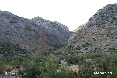 |
|
Type:
|
Cave |
|
Altitude:
|
300 m |
|
Region:
|
Mediterranean |
|
Province:
|
Antalya |
|
District:
|
Merkez |
|
Village:
|
Yagca |
|
Investigation Method:
|
Excavation |
|
Period:
|
Late |
|
|
|
 |
|
| The 22x17 m cave; lies in Öküzkakligi Mevkii; 1 km northwest of Somakli of Yagca village; northwest of Antalya. The mouth of the cave looks towards southwest. A small sondage was made near the entrance under the leadership of K. Kökten in 1957. He claims that there are finds dating to the Chalcolithic Age at the uppermost layers. However; it is not for sure whether a Chalcolithic Age layer exists or not. The site dates to the 8/9th phases in ASPRO. It is listed in the registered archaeological sites inventory prepared by Ministry of Culture and Tourism. |
| Location: This cave-site lies southwest of the city of Antalya; 1 km northwest of the Somakli neighborhood of the village of Yagca; 1 km west of the neighborhood of Kocaköy and 2 km south-southwest of the Karain Cave. The location area of the cave is called Öküzkakligi Mevkii. |
| Geography and Environment: The Çarkini Cave lies in the limestone outcrop of Mount Katran; which lies northwest of the city of Antalya. The mouth of the cave faces south. It has been reported that the cave is difficult to reach because it lies 190 m above the terrace and because the entrance is partially blocked by limestone slabs. The height of the cave is questionable but it is reported the cave is 22 m long and 17 m wide. There is a small terrace by the cave entrance. The Kisrakdöllügü River flows beneath. The inhabitants of this cave may have used this stream as a water source. |
| History: |
| Research and Excavation: |
| Stratigraphy: |
| Small Finds: |
| Remains: |
| Interpretation and Dating: |