|
©The Archaeological Settlements of Turkey - TAY Project
|
|
|
|
|
|
Çarkini |
|
|
For site maps and drawings please click on the picture...  |
For photographs please click on the photo... 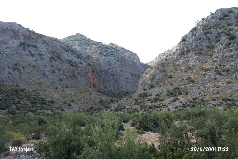 |
|
Type:
|
Cave |
|
Altitude:
|
300 m |
|
Region:
|
Mediterranean |
|
Province:
|
Antalya |
|
District:
|
Merkez |
|
Village:
|
Yagca |
|
Investigation Method:
|
Excavation |
|
Period:
|
ÜP EP |
|
|
|
 |
|
| Location: This cave-site lies southwest of the city of Antalya; 1 km northwest of the Somakli neighborhood of the village of Yagca; 1 km west of the neighborhood of Kocaköy and 2 km south-southwest of the Karain Cave. The location area of the cave is called Öküzkakligi Mevkii. |
| Geography and Environment: The Çarkini Cave lies in the limestone outcrop of Mount Katran; which lies northwest of the city of Antalya. The mouth of the cave faces south. It has been reported that the cave is difficult to reach because it lies 190 m above the terrace and because the entrance is partially blocked by limestone slabs. The height of the cave is questionable but it is reported the cave is 22 m long and 17 m wide. There is a small terrace by the cave entrance. The Kisrakdöllügü River flows beneath. The inhabitants of this cave may have used this stream as a water source. |
| History: |
| Research and Excavation: In 1957; Kiliç Kökten opened a small test trench in the cave. Even though detailed excavation reports have not appeared; the stratigraphy has been published. The uppermost layer in this cave is Chalcolithic and overlies the Neolithic. Below this are Upper Palaeolithic levels. It is not indicated whether virgin soil was reached. Another team; directed by Isin Yalçinkaya; Ilhan Kayan; Angela Minzoni-Deroche; resumed excavations at the site in 1984. The excavation of the cave and the sifting of Kökten's spoil allowed for a more careful collection of the remaining artifacts such as chipped stone debitage products and pottery; unnoticed by Kökten. Yalçinkaya explains that most of the cultural deposit had already been excavated by Kökten [Yalçinkaya 1995a:63]. From the remaining artifacts; Yalçinkaya believes the Palaeolithic levels at the site fall between the Middle Palaeolithic and the Epipalaeolithic. Future stratigraphic excavations will reveal the sequencing of these strata. It takes place in the registered archaeological sites list prepared by Ministry of Culture and Tourism. |
| Stratigraphy: |
| Small Finds: Kökten assigned all the finds from the Çarkini Cave to the Aurignacien. The 1984 re-excavation and sifting of the soil yielded 215 chipped stone fragments. There were no complete tools and all remainders were fragmentary pieces and debitage products which indicate that the former were preferred and collected by Kökten. Although Yalçinkaya; Kayan and Minzoni-Deroche do not strongly disagree with Kökten's conclusion that the earliest strata in the cave is Upper Palaeolithic; some rhyolite flakes; blades; bladelets and cores as well as one Levallois flake and core fragment led them to propose the possibility of a Middle Palaeolithic Layer [Yalçinkaya 1995a:65]. The data suggests that there may also have been some Epipalaeolithic activity in this cave. |
| Remains: |
| Interpretation and Dating: |