|
©The Archaeological Settlements of Turkey - TAY Project
|
|
|
|
|
|
Maltepe / Hacioglu |
|
|
For site maps and drawings please click on the picture...  |
For photographs please click on the photo... 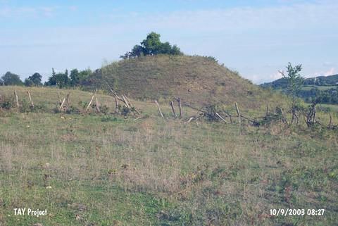 |
|
Type:
|
Mound |
|
Altitude:
|
190 m |
|
Region:
|
Black Sea |
|
Province:
|
Sinop |
|
District:
|
Merkez |
|
Village:
|
Hacioglu |
|
Investigation Method:
|
Survey |
|
Period:
|
|
|
|
|
 |
|
| It lies east of Hacioglu (Hacioglan) Village; 3 km east of the Sinop-Erfelek motorway; about 10 km south of Sinop Province. Maltepe is a large and complex Chalcolithic site in the foothills between the east coast of Sinop promontory and the Karasu river valley. It was revisited in 2006 by Doonan et al. [Doonan et al. 2008:133]. Samples were taken from two main areas of the site: (1) the upper mound which has turned up evidence of an extensive limestone bracelet industry yand (2) the lower terrace; which contains most of the evidence for a settlement. Two of the samples from the 2006 season have been tentatively dated. Together with the previously dated sample from the site a 5th/4th millenium date may be tentatively sugegsted for early occupation here; slightly earlier than conventional dating based on typological factors [Doonan et al. 2008:134]. It takes place in the registered archaeological sites list prepared by Ministry of Culture and Tourism. |
| Location: |
| Geography and Environment: |
| History: |
| Research and Excavation: |
| Stratigraphy: |
| Small Finds: |
| Remains: |
| Interpretation and Dating: |