|
©The Archaeological Settlements of Turkey - TAY Project
|
|
|
|
|
|
Cendere Magarasi |
|
|
For site maps and drawings please click on the picture...  |
For photographs please click on the photo... 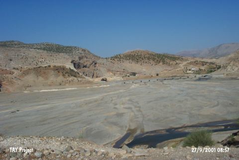 |
|
Type:
|
Cave |
|
Altitude:
|
500 m |
|
Region:
|
Southeastern Anatolia |
|
Province:
|
Adiyaman |
|
District:
|
Kahta |
|
Village:
|
Kilisik |
|
Investigation Method:
|
Excavation |
|
Period:
|
|
|
|
|
 |
|
| It stands on a rock next to the Roman bridge; being used today; over the Cendere Stream; a branch of the Kahta Stream; 35 km northeast of Adiyaman Province. It is one of the caves over the northwestern foot of the bridge. During a small sounding; inside the cave; carried out by F.K. Dörner and R. Naumann in 1963; in depths between 1.6-2.0 m; flintstone tools and artifacts dating from the EBA were recovered. No detailed report was published about the finds (See Neolithic Age Finds; Harmankaya et al. 1997:Cendere). It is listed in the inventory of the registered archaeological sites prepared by Ministry of Culture and Tourism. |
| Location: This site is 35 km northeast of the city of Adiyaman; near the Cendere Bridge which spans across Cendere Stream; a branch of Kahta Stream. On a 1:100;000 map; on map section M 41; there are numerous symbols indicating the presence of caves on the southern slopes of the rock outcrops northwest of the bridge and the northern slopes of the rock outcrop west of the bridge. It is possible to easily reach this site via the asphalt highway to Kahta and Nemrut Dag. |
| Geography and Environment: The cave is small and lies northwest of the Roman Bridge which still being used and spanning over the Cendere Stream (Chabines Flumen; in antiquity). The exact location has not been reported. The dimensions of the cave have not been reported. |
| History: |
| Research and Excavation: |
| Stratigraphy: |
| Small Finds: |
| Remains: |
| Interpretation and Dating: |