|
©The Archaeological Settlements of Turkey - TAY Project
|
|
|
|
|
|
Cendere Magarasi |
|
|
For site maps and drawings please click on the picture...  |
For photographs please click on the photo... 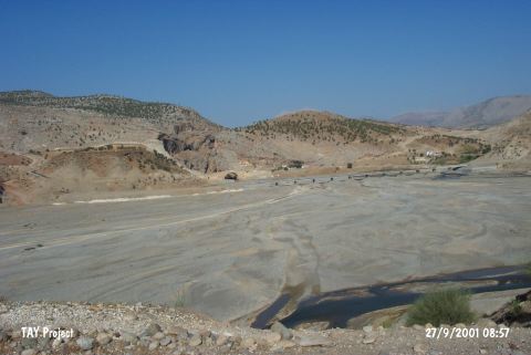 |
|
Type:
|
Cave |
|
Altitude:
|
500 m |
|
Region:
|
Southeastern Anatolia |
|
Province:
|
Adiyaman |
|
District:
|
Kahta |
|
Village:
|
Kilisik |
|
Investigation Method:
|
Excavation |
|
Period:
|
Ceramic |
|
|
|
 |
|
| Location: This site is 35 km northeast of the city of Adiyaman; near the Cendere Bridge which spans across Cendere Stream; a branch of Kahta Stream. On a 1:100;000 map; on map section M 41; there are numerous symbols indicating the presence of caves on the southern slopes of the rock outcrops northwest of the bridge and the northern slopes of the rock outcrop west of the bridge. It is possible to easily reach this site via the asphalt highway to Kahta and Nemrut Dag. |
| Geography and Environment: The cave is small and lies northwest of the Roman Bridge which still being used and spanning over the Cendere Stream (Chabines Flumen; in antiquity). The exact location has not been reported. The dimensions of the cave have not been reported. |
| History: |
| Research and Excavation: In 1963; a small excavation was conducted at the site under the direction of F. K. Döner and R. Naumann. It is listed in the inventory of the registered archaeological sites prepared by Ministry of Culture and Tourism. |
| Stratigraphy: Early Bronze Age material lies 160-200 cm beneath the current floor of the cave while Neolithic finds are 200-230 cm beneath the surface. |
| Small Finds: Pottery: The cave yielded Syrian-type dark burnished ware. Detailed information has not been provided. |
| Remains: |
| Interpretation and Dating: The site has been placed in the fifth and sixth periods in ASPRO; which is equivalent to uncalibrated 8;000-7;000 BP [Hours et al. 1994:138]. Until a site report specific to the cave is published; the dating of this site to the Neolithic should be viewed with skepticism. |