|
©The Archaeological Settlements of Turkey - TAY Project
|
|
|
|
|
|
Beçin |
|
|
For site maps and drawings please click on the picture... 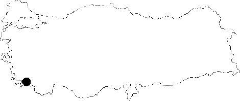 |
For photographs please click on the photo...  |
|
Type:
|
City |
|
Altitude:
|
m |
|
Region:
|
Aegean |
|
Province:
|
Mugla |
|
District:
|
Milas |
|
Village:
|
Beçin |
|
Investigation Method:
|
Excavation |
|
Period:
|
Geometric Hellenistic |
|
|
|
 |
|
| Location: It is located at the Beçin Village; 5 km south of the Milas District of the Mugla Province [Akarca 1971:1]. |
| Geography and Environment: Founded on the projection of a plateau; 200 m high from the Milas Plain; the city is divided by a valley from both directions. The Beçin plateau opens into the Agacliyuk Plain to the south. It is very rich in water. The water was transported by aqueducts to Mylasa. The land of the plateau is not arable [Akarca 1971:25; 30]. |
| History: |
| Research and Excavation: It was visited by Chandler during the 18th century; followed by a survey carried out by Robert in 1930s; and by Cook in 1959. Some tombs were uncovered during the highway construction between Milas and Oren in 1953. A tomb was uncovered; yielding finds from the Late Geometrical and Sub-Geometrical Periods during the excavations conducted by Akarca in 1965. Another excavation carried out by Kizil in 1994 yielded a chamber grave with dromos at the Kepezalti Mevkii. |
| Stratigraphy: |
| Small Finds: |
| Remains: Beçin consists of a castle; a city surrounded by a city wall; and a quarter located at Kepez; at the next valley to the east [Akarca 1971:24]. The extant remains include a city wall or a fortress wall extending 20-30 m along the eastern slope of the castle located over a travertine rock in front of a projection of the plateau where the city of Beçin is situated; and the temple under the castle. It was determined that the settlement dates as early as the end of the 8th century BC based on the burnished black glazed potsherds from the Late Geometrical Period; Orientalizing Period and 5th Century uncovered during the investigations carried out between the eastern slope of the castle and the western slope of Kepez; and thus it was concluded that the castle and the tombs below the plateau are interrelated. Several wall remains built in dry technique were uncovered during the investigations carried out in the cemetery. It was suggested that it might have belonged to a rural settlement dating back to the period following the Geometrical Period [Akarca 1971:4; 24-25]. City wall: It is suggested that the wall remains extending 20-30 m long on the eastern slope of the castle; might have belonged to an earlier fortress; and there should have been a fortress in this plateau lying to the south of Mylasa to protect Mylasa. The wall is dated back to the 4th century BC because of its lintel course [Akarca 1971:25]. Temple/Sanctuary Area: The temple located to the southeast of the rocks with a defense wall partly from the Mentesogullari Period extends in the northeast-southwest direction. During the investigations; architectural traces such as foundation walls; a stereobate made of ashlar limestones; stylobate blocks of Sodra marble and crepis stairs were found as well as four stones for orthostate. The foundation walls and the inner structure of the building indicate that it probably dates back to the 4th century BC; however a frieze fragment from the Archaic Period indicates an earlier temple. Therefore; it is considered to have had two phases. With the use of limestone for the inner; and of marbles for the outer parts; it resembles the Temple of Hisarbasi in Mylasa. The investigators presumed that the temple had a peripteral plan. The architectural elements of the temple were used as reused material for the construction of the present village of Beçin during the Middle Age [Akarca 1971:26-28]. It is controversial to which god/goddess the temple was connected. Chandler who visited the site during the 18th century and Cook who conducted investigations in 1959 reported that it was a temple of Zeus Karios; while Robert suggested that the temple with a single Corinthian column at Hisarbasi may have been connected with Zeus Karios or Zeus Stratios [Robert 1953:412-413]. Laumonier; believing that the imperial cults are connected with the earliest cults; proposed that the Temple of Zeus Karios is located near the Augustus and Roman Temples at Hisarbasi [Laumonier 1958:43]. According to Akarca; the Temple of Zeus Karios is in Corinthian order; depending on the depictions of the two coins he analyzed whereas the temple in Beçin was erected in the Ionic order; based on the frieze fragments uncovered; thus it shouldn't be related with the Temple of Zeus Karios. The investigator believes that the temple in Hisarbasi might have been connected with Zeus Karios [Akarca 1971:28]. Also found is a corner fragment from a rectangular altar with a voluted corner as a reused material at Berçin; which probably belongs to the temple [Akarca 1971:29]. The six marble steps at the entrance to the castle are presumably from the temple. Some Attic black glaze potsherds dating to the 8th-4th centuries BC were found. Also some parts obviously from the Protogeometrical and Geometric Periods were uncovered during the excavations in the cemetery in the vicinity. All of these finds indicates an early settlement. Additionally; presence of fragment of an obsidian cutting tool shows that the initial settlement dates back to 2000 BC [Bean 2000:36]. Necropolis/Graves: Several graves were uncovered during the road construction on the Milas-Oren road below the plateau where Beçin is located. The investigations revealed that there is a cemetery scattered into a large area; occupied between the Geometric Period and the 4th century BC During the excavations; two sarcophagi and three pit graves were found. The sarcophagi are of family tombs; and based on the potsherds they are from the Late Geometrical Period. The skeletons were placed with no specific arrangement. It was found out that the earlier ones were moved backward in order to place the newer bodies [Akarca 1971:3]. It is reported that alikes of one of the fibula collected from the grave no. 3 were found in Termera [Akarca 1971:15]. 100 m east of these two graves lies a child's tomb from the Sub-Geometric Period. The pit graves are located 1 km east of these three graves. Both are dated to the 3rd century BC Chamber graves were uncovered during the illicit diggings on the tumuli located at Armutcuk to the southern part of the plateau. One of them consists of a single chamber with a vertical dromos. The ceiling is covered with two beams. The larger of the two tumuli located at the Dirvalani Mevkii to the north of the plateau has also been destroyed due to illicit digging. The local name for the large tumulus; which has a 40-50 m diameter is "Dagarcik Tasi". It is covered by earth up to 3 m high; then a pile of stones of 0.5 m thick. It consists of two chambers in the north-south direction. A marble sarcophagus was found in the middle of the larger chamber. The investigator found out that it was erected by the same technique found at Damlacik; located at the skirts of Sodra and Ortaokul in Milas. The ceiling of these type of graves are made of stone blocks seating on two beams. It was suggested that the Armutcuk and Dirvaalani tumuli can be dated back to the Hellenistic Period [Akarca 1971:34-36]. While digging pits for a septic tank for a house at parcel no. 1334 at the Kepezalti Mevkii; an underground chamber grave with dromos was uncovered. It consist of a dromos measuring 1.69x1.41 m; and a burial chamber measuring 2.92x2.84 m. The blue-white marble naturally found at the Sodra Mountain near Milas was used as construction material. It is estimated that the marble bloks should have been connected by axle clouts. The floor is paved with marble plates. The studies on dromos revealed that the entrance was covered by two vertically placed marble plates. The burial gifts being scattered around; and some traces of breaking in on the door indicate earlier penetration into the grave by robbers. On the block above the entrance to the burial chamber; it records "Adas; daughter of Menippos prepared (this chamber) for herself; her children and grandchildren" in Greek. The entrance door to the burial chamber has two marble leaves. Being a pseudo-wooden door; the marble door is similar to the ones in the Mylasa Ortaokul; Trachian and Lydian tumuli. There are dead beds on three sides of the burial chamber. The bed accross the entrance is larger than the other two. Two burial traditions were used in the burial chamber; the first one directly into the burial beds in the form of sarcophagus; and the second one is the cremation. Two stamnoi and one osthotek were found as indications of the cremation. As it is similar to the Ortaokul; Damlacik and Alabanda graves in terms of masonry; it is dated back to the last quarter of the 4th century BC Presence of burial gifts from later periods indicates that it had been used for a longer period of time. In conclusion; it occupied between the last quarter of the 4th century BC and the 1st century AD [Kizil 1996:255-260]. Among the finds from the dromos are lamps of grey paste; one unguentarium; one kylix; one long vase with double handles and one bronze flat door handle. The sarcophagi in the burial chamber yielded 23 gold necklace leaves with zigzag segments and pointed tips; pseudo-wooden marble osthotek; one amphoriskos; 3 unguentariums; one lamp; one plate; one stamnos with a burnt bone inside and one stamnos with bones burnt in the area in the middle of the burial chamber. |
| Interpretation and Dating: |