|
©The Archaeological Settlements of Turkey - TAY Project
|
|
|
|
|
|
Tatarli Höyük |
|
|
For site maps and drawings please click on the picture...  |
For photographs please click on the photo... 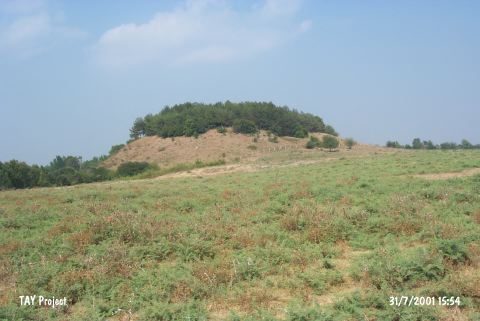 |
|
Type:
|
Mound |
|
Altitude:
|
80 m |
|
Region:
|
Mediterranean |
|
Province:
|
Adana |
|
District:
|
Ceyhan |
|
Village:
|
Kösreli |
|
Investigation Method:
|
Excavation |
|
Period:
|
|
|
|
|
 |
|
| Location: The mound lies in Tatarli Village; 9 km northwest of Toprakkale; east of Adana Province. |
| Geography and Environment: Tatarli Höyük is a large 35 m high flat mound with a 100x75 m base. The base of the mound is basalt. There ruins of a rectangular structure lie on top of the mound. North of the mound is a swamp. |
| History: |
| Research and Excavation: The site was discovered in 1951 by M.V. Seton-Williams during his surface survey in Cilicia. It takes place in the registered archaeological sites list prepared by Ministry of Culture and Tourism. The excavations were started in 2006 by S. Girginer. |
| Stratigraphy: The finds from the surface of the mound were assigned to the Byzantine; Roman; Hellenistic Periods; the Iron; Late Bronze and Middle Bronze Age as well as the Chalcolithic and Neolithic Periods. |
| Small Finds: The water channel belonging to IA was exposed in Trench BA 173 during the 2011 studies. It was built with a single row of stones. One of the stone rows is located on the north and the other one is 35 m south of that and the water channel was formed as double lines with a single row stones. The stone row forming the north line is 7.30 m in length. The other line on the south, which was formed with a single row of basalt stones, is 7 m in length. This row is made of small stones as well. IA materials were found in the fills of Room M2 and Room M3 during the stepped trench excavations. In 2013, the studies conducted around Structure A yielded finds dated to IA. However, it is quite hard to relate these finds to architectural remains. The architectural remains of IA have been severely damaged due to the structures belonging to Hellenistic Period. To the south of the sacred road, a room, the floor of which contains in situ finds, dated to Middle IA was exposed for the first time. The room covers an area of 12 square meters. A post hole was found in the center of the room. There are two entrances located in the east and west [Girginer et al. 2015:436]. Pottery: Cream slipped crater with paint decoration and 4 lugs, a basket-handled small pitcher with black painted decoration on red, a stone vessel with three feet and a red slipped bowl were found in the room exposed in the south of the sacred road [Girginer et al. 2015:436]. |
| Remains: |
| Interpretation and Dating: |