|
©The Archaeological Settlements of Turkey - TAY Project
|
|
|
|
|
|
Buruncuk / Larisa |
|
|
For site maps and drawings please click on the picture...  |
For photographs please click on the photo... 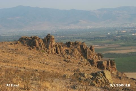 |
|
Type:
|
Flat Settlement |
|
Altitude:
|
90 m |
|
Region:
|
Aegean |
|
Province:
|
Izmir |
|
District:
|
Menemen |
|
Village:
|
Buruncuk |
|
Investigation Method:
|
Excavation |
|
Period:
|
EBA III |
|
|
|
 |
|
| It is close to Buruncuk of Menemen District; 28 km north of Izmir Province. Ramsay who visited the region earlier claimed that the ancient city of Larisa is located here. The excavations interrupted in 1902 were continued from 1932. It has been laid out that the site was established as a village through the end of EBA [Böhlau 1933:191]. Based on the results of this excavation; D.H. French evaluated it among the EBA III settlements of Western Anatolia. The excavations didn't yield any coins and inscriptions to prove that it is the ancient city of Larisa. It takes place in the registered archaeological sites list prepared by Ministry of Culture and Tourism. |
| Location: It is located at the Buruncuk Village of the Menemen District, 28 km north of the provincial center of Izmir [Sevin 2001a:260]. |
| Geography and Environment: The Buruncuktepe on which the city of Larisa is located is the upper plain of a small nose like hill rising to the right after passing through the Gediz River. Buruncuktepe overlooks the Menemen Plain in all directions [Doger 1998:279]. |
| History: |
| Research and Excavation: |
| Stratigraphy: |
| Small Finds: |
| Remains: |
| Interpretation and Dating: |