|
©The Archaeological Settlements of Turkey - TAY Project
|
|
|
|
|
|
Hacilar Höyük |
|
|
For site maps and drawings please click on the picture...  |
For photographs please click on the photo... 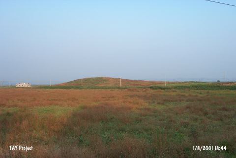 |
|
Type:
|
Mound |
|
Altitude:
|
90 m |
|
Region:
|
Mediterranean |
|
Province:
|
Adana |
|
District:
|
Ceyhan |
|
Village:
|
Merkez |
|
Investigation Method:
|
Survey |
|
Period:
|
|
|
|
|
 |
|
| It is a flat and big mound located while entering the Kürtkulak Valley; 1 km south of Ceyhan; east of Adana Province. It has been severely destroyed due to continuous ploughing. The materials collected from the surface were examined by M.V. Seton-Williams. Aside Chalcolithic Age; the presence of the Iron Age; the Roman and Byzantine Periods settlements was reported in accordance with the sherds collected. The Cannaanean-like blades [Seton-Williams 1954:156]; a feature of EBA; were accompanied with samples of the metallic ware recovered during the J. Mellaart's survey. It was researched again within the scope of "Adana (Ceyhan) and Kayseri (Develi) surveys" performed by S. Girginer et al. in 2005. The mound is10 m high; and measured 100x150 m. Many architectural building elements and a stone press fragment were found at the top of the hill. Obsidian fragments; and silex production waste were revealed in the mound; additionally a stone seal; and ceramics that date to the Chalcolithic age; EBA; and 2nd millenium BC; and Roman-Byzantien periods were found [Girginer 2007:174]. It takes place in the registered archaeological sites list prepared by Ministry of Culture and Tourism. |
| Location: |
| Geography and Environment: |
| History: |
| Research and Excavation: |
| Stratigraphy: |
| Small Finds: |
| Remains: |
| Interpretation and Dating: |