|
©The Archaeological Settlements of Turkey - TAY Project
|
|
|
|
|
|
Girharrin / Gülharrin |
|
|
For site maps and drawings please click on the picture...  |
For photographs please click on the photo... 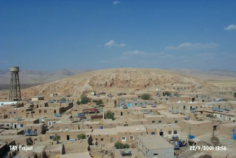 |
|
Type:
|
Mound |
|
Altitude:
|
450 m |
|
Region:
|
Southeastern Anatolia |
|
Province:
|
Mardin |
|
District:
|
Yesilli |
|
Village:
|
Ortaköy |
|
Investigation Method:
|
Survey |
|
Period:
|
|
|
|
|
 |
|
| It is located at the center of Ortaköy, lying to the immediate west of the motorway running between Mardin and Nusaybin, 11 km south-southeast of the provincial district of Mardin. Being 40 m high above the plain level, the mound measures 400x300 m in dimensions together with its terraces. The cone of the mound is 75x70 m in dimensions, with an oval shape. It rests on the western bank of the Rijli Stream. The Valley of Navala Kutte where the mound is located at its entrance, provides a natural passage to the northeast. Situated near the road so called the King's road, the mound has been heavily destroyed by the local people and treasure hunters. It is proposed that the name of the mound derives from the words Gir (hill) and Harrin (road), and it is also called Gülharrin. It is also claimed that it can be identified with the city of Huzirina referred in the Assyrian documents. Material dating to the 3rd-1st Millennia BC indicate presence of settlements dating to these periods. Sherds finds suggest that the settlement was part of the Northern Mesopotamia and Northern Syrian culture. It takes place in the registered archaeological sites list prepared by Ministry of Culture and Tourism. |
| Location: It lies in the center of the village of Ortaköy (Girharrin) Village located immediate west of the Mardin-Nusaybin motorway; 11 km south-southeast of the Mardin Province [Ay 1995:map at 27]. |
| Geography and Environment: It measures 40 m in height above the plain level and 400x300 m in dimensions including the terraces. The cone of the mound measures 75x70 m. It has an oval shape. It is located on the western bank of the Rijli Stream. The valley of Navala Kutte; where the mound is located at the entry; provides a natural alley to the northeast. It is close to the road called King's Road. The mound has been severely destroyed by the local villagers and treasure hunters. The name is suggested to derive from Gir (hill) and Harrin (road). It is claimed that the city of Huzirina mentioned in the Assyrian documents is located here. |
| History: |
| Research and Excavation: |
| Stratigraphy: |
| Small Finds: |
| Remains: |
| Interpretation and Dating: |