|
©The Archaeological Settlements of Turkey - TAY Project
|
|
|
|
|
|
Barcin Höyük |
|
|
For site maps and drawings please click on the picture...  |
For photographs please click on the photo... 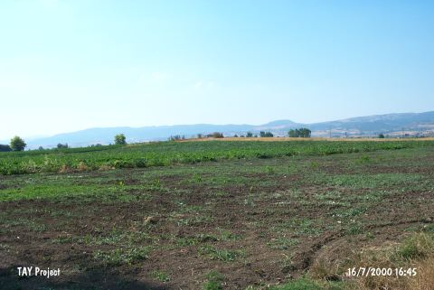 |
|
Type:
|
Mound |
|
Altitude:
|
192 m |
|
Region:
|
Marmara |
|
Province:
|
Bursa |
|
District:
|
Yenisehir |
|
Village:
|
Barcin |
|
Investigation Method:
|
Excavation |
|
Period:
|
|
|
|
|
 |
|
| It is located immediate south of the road between Yenisehir and Mentese; about 200 m south of Yenisehir-Bursa motorway; 4 km west of Yenisehir District; east of Bursa Province. The area is locally known as Üyecek Mevkii; and the mound as Üyecek Tepe. It measures 100x4 m and there is a survey point on top hill. It was discovered by K. Bittel; and investigated by J. Mellaart; J. Cullberg; D.H. French and M. Özdogan. Materials of the EBA II-III and the second millenium BC were collected from the surface. Sherds of the handmade Iznik ware were recovered. It is also referred to as Yenisehir the West. Investigations directed by Jacob Roodenberg on behalf of the Netherlands Institute in Turkey began in 2005. It is named as Barçin Höyük. One of the better preserved Late Chalcolithic layers contained a burial in hocker position and dated by radiocarbon analysis to 3850 BC [cat.une.edu.au/page/barcin%20hoyuk 4.12.2006; 15:00]. The excavations were restarted by the Istanbul Branch of Holland Research Institute in 2007. The excavations were concentrated inside the four adjacent trenches of 10x10 m in dimensions; and these revealed an archaeological level which was dated to three different periods. The uppermost level contained a cemetery that was dated to the Byzantine period. Right below this a Late Chalcolithic Period level followed. Within these levels which were poorly preserved a large kiln many smal hearths adobe brick walls and a ditch of approximately 2 m width were revealed. The ceramics of this period are important in terms of understanding the typology and chronology of the Souhern Marmara Region. There are levels underneath the Late Chalcolitic levels that are assumed to belong to the second half of the 7th millenium based on two 14C measurements and sherds analysis. As a result of the soundings it was found that this level was a little over 1 m in depth [Gerritsen-Özbal 2008:23-24]. In 2007, in newly opened Trench M11, the pottery from these two phases is Late Chalcolithic, with significant admixtures of heavily abraded late Neolithic sherds. The Late Chalcolithic pottery has its closest affinities with the Ilıpınar phase IV ceramics, which came from a cemetery, and is also similar to the Ware F and G assemblages from Demircihöyük. This places the occupation phase in the middle of the fourth century BC. Another interesting find from these levels is a copper or copper alloy axe [Gerritsen-Özbal 2009:459]. A Late Chalcolithic settlement is located in 2009 below the Byzantium Cemetery in Trench L12 having a single phase which is contemporary with the Late Chalcolithic remains. Remains of two furnaces and a poorly preserved adobe architecture are captured from this period [Öztan-Gerritsen 2011:199]. Animal bones captured during 2009 excavations are analysed and it is found out that only a few wild boars and nearly no domestic hogs existed during the Neolithic Age dating to 6300 BC. On the contrary, many domestic hogs existed in layers dating to Late Chalcolithic Period. A significant difference is found between the two periods [Öztan-Gerritsen 2011:202]. In 2011 season, the architectural structures found in Trench L10 are dated to Late Chalcolithic period. A tandoori in the shape of key with a diameter of 2 m was exposed. A floor, four postholes and a continuation of a mudbrick wall dated to Late Chalcolithic period (4th millennium BC.) were discovered in Trench M11. Three hearths dated to the same period were excavated in Trench M13 Özbal-Gerritsen 2013:159-163]. It takes place in the registered archaeological sites list prepared by Ministry of Culture and Tourism. |
| Location: This site lies east of the city of Bursa; 4 km west of the town of Yenisehir; 3-4 km south of the village of Barçin and about 200 m south of the Yenisehir-Bursa highway. |
| Geography and Environment: The Yenisehir Plain is 4 m high and has a 100 m diameter. There is a freshwater spring very close to the site. Another name for the site is Yenisehir or Bati Höyük. The area is locally known as Üyecek Mevkii; and the mound as Üyecek Tepe. There is a survey point on top of it. The geomorphological and geoarchaeological studies carried out in 2012 indicate that the vicinity of the mound was a swamp-like area [Gerritsen-Özbal 2014:471]. |
| History: |
| Research and Excavation: |
| Stratigraphy: |
| Small Finds: |
| Remains: |
| Interpretation and Dating: |