|
©The Archaeological Settlements of Turkey - TAY Project
|
|
|
|
|
|
Boy Tepe |
|
|
For site maps and drawings please click on the picture...  |
For photographs please click on the photo... 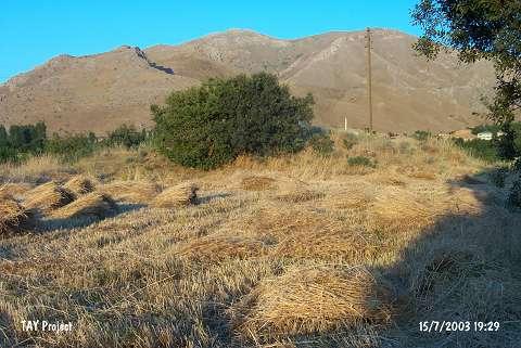 |
|
Type:
|
Mound |
|
Altitude:
|
910 m |
|
Region:
|
Eastern Anatolia |
|
Province:
|
Elazig |
|
District:
|
Merkez |
|
Village:
|
Degirmenönü |
|
Investigation Method:
|
Survey |
|
Period:
|
EBA I EBA II EBA III |
|
|
|
 |
|
| The mound lies 40 km east-southeast of Elazig; on the southern slope of Altinova; 500 m north of Yeni Elazig road; 700 m northwest of Degirmenönü (Zenteriç) village. The location of the site is known as Kiraç. West of the mound Körtepe and Norsuntepe settlements take place. It was discovered by R. Whallon - S. Kantman in 1967. The lake of the Keban Dam has no influence on the settlement. The site is also called as Boytepe and shown under Code 0 55 / 3 yielded deposits in an area of 150x75 m. Boytepe was included in the archaeological documents as it houses finds of the Aceramic Neolithic Age. Presence of the EBA I-II; Hittitian and Middle Age sherds recovered from the surface expose that the settlement had been occupied in various periods. A limited number of the Chalcolithic-EBA transition pottery and the Iron Age pottery was recovered. It is poor in the EBA III pottery. Also found are sherds with reserved slip decoration. It has been severely damaged as it has arable slopes. It should be excavated to reveal the layering of the Altinova Plain. |
| Location: This site is located approximately 40 km east-southeast of the city of Elazig; south of the Elazig-Bingöl highway and near the village of Degirmenönü (Zerteriç); a district of the Içme Municipality. The location of the site is known as Kiraç. North of the site is dam reservoir; west is Körtepe and Norsuntepe mounds. The survey code of the site is O 55 / 3. |
| Geography and Environment: This is a mound; partially flooded by the Keban Dam Lake; lying in the southeast corner of the Altinova Plain and on the northern flanks and terraces of Mount Mastar. Although the mound appears to look like an open-air site; it is actually comprised of several layers and is a fairly large and flat mound. The dimensions of the base are 150 m southeast-northwest and 50 m southwest-northeast while the height is approximately 2 m in the southeast [Whallon 1979:246]. The Murat Spring flows by the foot of the mound. Boy Tepe is comprised of two different topological characteristics. The southeastern corner is flat on top and is surrounded by rock scatters while there are several terraces on the northern and northwestern sides of the mound. The terraces might have been artificially created for agricultural fields and the scatters of rock might have been laid to prevent erosion. |
| History: |
| Research and Excavation: |
| Stratigraphy: |
| Small Finds: |
| Remains: |
| Interpretation and Dating: |