|
©The Archaeological Settlements of Turkey - TAY Project
|
|
|
|
|
|
Birecik Baraji Mezarligi |
|
|
For site maps and drawings please click on the picture... 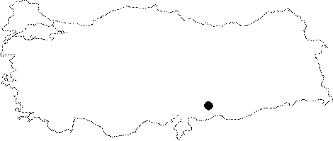 |
For photographs please click on the photo... 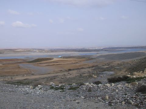 |
|
Type:
|
Cemetery |
|
Altitude:
|
460 m |
|
Region:
|
Southeastern Anatolia |
|
Province:
|
Gaziantep |
|
District:
|
Nizip |
|
Village:
|
Merkez |
|
Investigation Method:
|
Excavation |
|
Period:
|
EBA I EBA II |
|
|
|
 |
|
| Location: It lies about 800-100 m southeast of Birecik Dam where the Euphrates coming from the north bends toward the east; 10 km west of Bilecik District of Sanliurfa Province; 9 km east-northeast of Nizip District; about 45 km east of Gaziantep Province. It will not be submerged by the Dam. It has no specific name. The excavators named it after the dam nearby. |
| Geography and Environment: The cemetery starts 30 m far from the southwestern bank of the Euphrates and continues 200 m toward the southwest on a slope rising slightly to the west with a soft inclination. It is 10-15 m high from the river basin. It covers an area of ca. 250 m long in the east-west direction. The graves built into the red clay virgin soil have been completely covered by a 1-1.5 m thick alluvial conveyed by the seasonal streams from the Nizip Plateau in addition to the erosion. The cemetery is in a locked position. |
| History: |
| Research and Excavation: The cemetery locked by alluvial deposit was maintained unnoticed for thousands of years; and brought to light during the removal of the soil required for the construction of the dam. During this removal process realized by dozers; the graves particularly on the northwestern part of the cemetery were completely demolished. The Museum of Gaziantep conducted an immediate salvage excavation in this area. 312 graves were uncovered and documented in an area of 3 ha. by a team under K. Sertok and R. Ergeç. Due to the insistent removal of soil by the construction company; the excavation was carried out in a very quick period. |
| Stratigraphy: The excavators report that all the graves are contemporary with each other; and probably the cemetery was used for a short period of time. The number of graves overlapping each other is very small and some houses two burials. It can be suggested that the graves were marked by stone or wooden posts after covered by earth. The graves are almost in the same level; therefore it is a single layered cemetery. |
| Small Finds: Human Remains: No trace of any settlement was discovered in the neighbourhood of the cemetery. It is suggested that such a settlement probably disappeared during a great flood of the Euphrates or it was utilized by several settlements in the vicinity as a common cemetery [Sertok-Ergeç 1999:89]. The graves were built almost in the northwest-southeast direction. Some areas are crowded [Sertok-Ergeç 1999:map at fig 2]. Between some graves; there are depressed areas varying from 1 to 7 m in size. The circular pits; 1-2 m wide and 1-2 m deep; can be related with the burial ceremony according to the excavators. The pits are full of sherds; tools chipped from stones; underfired fragments of bricks; animal bones and heavy ash. The pit on the west of the grave no. M 237 was encircled with a row of stones. Based on these; it is suggested that a ceremony was performed during burials. Two types of graves were recovered; plenty of cist graves and limited number of big pithos graves encircled with stone rooms. The cist graves were built by standing big stone plates to the walls of a four-cornered pit dug into the virgin soil. Although there are some minor distinctions; the southern and western walls were carefully built by a single flat stone. The horizontal big stone on the eastern wall was placed higher than the others. They were capped by a few or a single big stone. The spaces between were filled with small stones. The size of the graves varies. Some measure 110x60 cm in inner dimensions and 40 cm in height up to 220x160 cm in dimensions and 100 cm in height. The average size is 130x80x50 cm. They have no dromos and entrance. The number of jar/pithos graves is 13 only. They were built by interring big food or storage pithoi into the spaces between the cist graves. They have a round base; large body; wide mouth and short neck. Amazing is that these pithoi were encircled with stone plates just like the cist graves. They house mostly child burials. Two of them house infant skeletons. They were capped by sherds; reversed fruit-stands or small flat stone plates. They were reinforced by small stones. The skeletons in the cist graves are disarticulated. Only 50 of 226 graves uncovered during the 1997 excavation yielded human skeletons; in small quantities. Only a few skeletons were almost not disarticulated. Some graves even didn't yield any bones. Some graves house single burials whereas some others between 2 and 9 burials. Some of them have bones in mass; some only a few scattered around. Excavators presume that this may result from various reasons such as the flood of the Euphrates; roots of the plants and activities of some animals. In general; when a grave is re-used; the bones of the former burial are put aside. The burials which were recovered intact were interred in contracted position leaning on their right/left as their cloths and accessories were on. Most of them are adult burials; both male and female. The skeletons were analysed by the Paleoantrapology Department of the Language; History and Geography Faculty; University of Ankara under A. Sevim [Sevim et al. 1999:65-73]. Their age ranges between 25 and 45. There are traces of knives applied intentionally on the bones. Grave Goods: The personal belongings; weapons and vessels produced as grave goods were left near the burials. The vessels are placed in a row on the north or in groups on the northwest. The spearheads are recovered from the northern or southern side in parallel to the wall while the pins are scattered around and ornaments like beads are recovered near the skull or the neck. As a result of two seasonal excavations; intact or almost intact vessels exceeding 5000 pieces that can be grouped into five were recovered. All were produce of slow-turning wheel. The most common ware is the plain simple ware. The color of the paste varies from matt brown to red. The bottom of some vessels and fruit-stands produced by this ware is retouched by flint blade. Forms of fruit-stands; jars; bowls and low footed cups are common. The second group is the reserved slip decorated ware. Horizontal; vertical and diagonal bands were preferred as decorations. The fruit stands between 8 and 60 cm long; forms like squat footed jars; paste and surface colors resemble the simple plain ware. 15 samples of the painted ware similar to the Nineveh V ware represent the third group. The fourth group is the dark brown red-red washed ware. The fifth group is represented by incision decorated vessels. Copper/bronze finds include pins exceeding 400 pieces; spearheads tangled in two compartments with a leaf shaped blade; spit-like spearheads; flat axes; amulets and beads. Animal headed pins demonstrate the extent this community achieved in mining. Animal and human figurines in clay; stone beads and Jamdat Nasr type cylindrical seal in limestone are among other major finds. |
| Remains: |
| Interpretation and Dating: The excavators report that likes of these grave finds are found in the cemeteries of Kargamis; Kara Hasan; Hacinebi and Hassek Höyük and building levels VIA-VIA of Arslantepe; and based on this comparison; they evaluate the cemetery in EBA I-II; largely in EBA I [Sertok-Ergeç 1999:94-95]. It is also reported that the cemetery was used for a few centuries at the beginning of the third millennium BC. The analysis on the human bones suggests the presence of cannibalism based on the traces of knives and breaks aiming to get out the bone marrow [Sevim et al. 1999:68]. No finds supporting this thesis were found at EBA graves. |