|
©The Archaeological Settlements of Turkey - TAY Project
|
|
|
|
|
|
Küçük Hedbe |
|
|
For site maps and drawings please click on the picture...  |
For photographs please click on the photo... 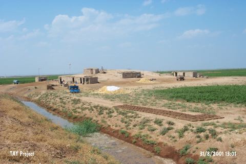 |
|
Type:
|
Mound |
|
Altitude:
|
470 m |
|
Region:
|
Southeastern Anatolia |
|
Province:
|
Sanliurfa |
|
District:
|
Harran |
|
Village:
|
Seferköy |
|
Investigation Method:
|
Survey |
|
Period:
|
|
|
|
|
 |
|
| The mound is located in Seferkoy (Hedbe), south-southeast of Sanliurfa and 9 km south of Harran (Altinbasak) district. The conical mound with a diameter of 115 m is 6 m higher than the plain level of Harran. According to N. Yardimci; intensive ploughing around and on the skirts of the mound may cause the mound to vanish in close future. It is discovered in 1990 during tha Harran Plain Survey conducted by Yardimci. Neolithic Age [Harmankaya et al. 1997:Küçükhedbe]; Halaf Period; EBA; Iron Age and Medieval Age pottery finds are collected from the surface. It takes place in the registered archaeological sites list prepared by Ministry of Culture and Tourism [Yardımcı 2004:46-47]. |
| Location: The site lies 700 m northwest of Büyükhedbe; 9 km south of the district of Harran (Altinbasak); south-southeast of the center of Sanliurfa. Büyükhedbe and Küçükhedbe were noted reverse. |
| Geography and Environment: There is not enough information about its location. It is reported that the mound is in the Harran plain; and measures 115 m in diameter and 6 m in height. It is also mentioned that because of the surrounding fertile fields and plowing the mound is in danger of destruction. |
| History: |
| Research and Excavation: |
| Stratigraphy: |
| Small Finds: |
| Remains: |
| Interpretation and Dating: |