|
©The Archaeological Settlements of Turkey - TAY Project
|
|
|
|
|
|
Beyköy |
|
|
For site maps and drawings please click on the picture...  |
For photographs please click on the photo... 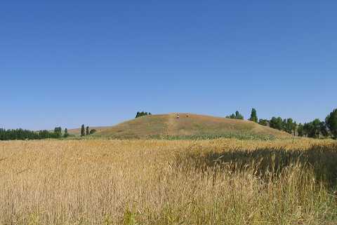 |
|
Type:
|
Mound |
|
Altitude:
|
1085 m |
|
Region:
|
Aegean |
|
Province:
|
Afyonkarahisar |
|
District:
|
Ihsaniye |
|
Village:
|
Beyköy |
|
Investigation Method:
|
Survey |
|
Period:
|
EBA II |
|
|
|
 |
|
| It lies 2.5 km south of Beyköy Village; 4 km northeast of Ihsaniye District; 33 km north of Afyonkarahisar Province as the crow flies. It is located on the mountain; east of the plain between Afyon and Kütahya. To its west-northwest flows the Anöz Stream. It was discovered by J. Mellaart. It was included in the EBA II settlements. It was also visited by D.H. French. It is renown by the hieroglyph inscriptions belonging to the Hittite Empire. It is probable that the mound was the capital of a local kingdom in Western Anatolia in the second millennium BC It is a big mound. The site was re-documented in 2005 during the fieldwork of Phygrian Valley Tourism Zone Project. It takes place in the registered archaeological sites list prepared by Ministry of Culture and Tourism. |
| Location: |
| Geography and Environment: |
| History: |
| Research and Excavation: |
| Stratigraphy: |
| Small Finds: |
| Remains: |
| Interpretation and Dating: |