|
©The Archaeological Settlements of Turkey - TAY Project
|
|
|
|
|
|
Beyköy |
|
|
For site maps and drawings please click on the picture...  |
For photographs please click on the photo... 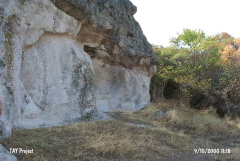 |
|
Type:
|
Single Findspot |
|
Altitude:
|
820 m |
|
Region:
|
Aegean |
|
Province:
|
Kütahya |
|
District:
|
Tavsanli |
|
Village:
|
Beyköy |
|
Investigation Method:
|
Survey |
|
Period:
|
AP |
|
|
|
 |
|
| Location: This site is 3 km northwest of the town of Tavsanli; northwest of the city of Kütahya and west of the village of Beyköy. It lies on a rocky outcrop on the flat area north of it; at the foot of the northern flanks of Mount Manastirtepe; west of the Tavsanli-Domaniç highway. |
| Geography and Environment: The village of Beyköy lies in the flat Tavsanli Plateau along a chain of low mountains oriented southeast-northwest. The find spot is locally known as Asar Tepe. |
| History: |
| Research and Excavation: Turan Efe found a variety of chipped stone tools during his 1988 surface survey in this area. It takes place in the registered archaeological sites list prepared by Ministry of Culture and Tourism. |
| Stratigraphy: |
| Small Finds: The tools collected by Efe are slightly rougher and have thicker patinas than other tools from this area. The sharp edges of these tools; which have been assigned to the Lower Palaeolithic; have been abraded indicating that the artifacts were carried to their find locations by natural processes. |
| Remains: |
| Interpretation and Dating: |