|
©The Archaeological Settlements of Turkey - TAY Project
|
|
|
|
|
|
Beldibi / Kumbucagi |
|
|
For site maps and drawings please click on the picture... 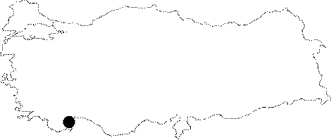 |
For photographs please click on the photo... 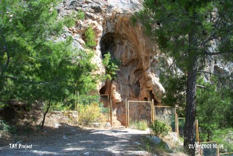 |
|
Type:
|
Rock Shelter |
|
Altitude:
|
30 m |
|
Region:
|
Mediterranean |
|
Province:
|
Antalya |
|
District:
|
Kemer |
|
Village:
|
Beldibi |
|
Investigation Method:
|
Excavation |
|
Period:
|
Ceramic |
|
|
|
 |
|
| Location: This rock shelter site is 24 km southwest of the city of Antalya; 3 km north of the village of Beldibi; a village 800 m inland from the shore. It lies at the northern point of a long and thin beach; on a limestone outcrop by the sea; approximately 100 m from the shore. The shelter; which today is hidden by the forest vegetation around it; is difficult to find. The Antalya-Kemer highway is very close to the site. It is possible to reach the rock-shelter by walking down from this highway. |
| Geography and Environment: Because the limestone outcrop that the rock shelter lies in is locally known as Kumbucagi; this name has been chosen by the site director; Bostanci. However; in several publications the site has also been referred to as Beldibi; after the name of the closest village. There is a small cave; 5 m wide; 4 m deep and 3.5 m high; 12 m above the rock shelter. This cave has a 1.2 m soil deposit within it. It is in a very difficult place to reach. The rock shelter; on the other hand; lies in the terrace beneath; which has a semicircular base and which slopes towards the sea. The shallow rock shelter is 3 m wide. This is where the excavations were conducted. Although Bostanci notes that the depositional fill in the rock shelter is 5 m deep; in his site report he notes that he excavated to 6.20 m. The cave and the rock shelter are both in an area that is suitable for hunting and protection. It has not been reported whether there is a nearby water source. This area was used as a temporary campsite or as a habitation area by Upper Palaeolithic (?); Epipalaeolithic and Neolithic hunters. |
| History: |
| Research and Excavation: There are paintings on the back wall of this rock shelter. Excavations here; with an initial 1.5x1.5 m trench by the wall paintings; began in 1959; three years after the site was discovered by E.Y. Bostanci [Bostanci 1959a:145]. Because the trench became too narrow for the removal of soil as it got deeper; a new trench had to be opened. This trench; perpendicular to the first is 2x2.5 m in size. In 1959 excavations stopped at 452 cm below the surface. Bostanci reports that the 1960; 1966 and 1967 excavations reached a depth of 6 m. The stratification of the soil in the upper cave was determined by the cross-section of a large hole opened in the cave; probably by treasure-hunting villagers. Most of the spoil the villagers excavated was thrown out of the cave. It takes place in the registered archaeological sites list prepared by Ministry of Culture and Tourism. |
| Stratigraphy: The excavation of the rock shelter yielded at least seven and possibly eight strata. The top three strata consist of two layers. Bostanci has labeled these layers with numbers (For the stratigraphy of Beldibi/Kumbucagi see Harmankaya-Tanindi 1996:Beldibi). Layers B1 and B2 of Stratum B have been assigned to the Neolithic by the excavation director. This stratum lies immediately beneath 53 cm thick Stratum A; which yielded a mixture of modern and classical finds. It is reported that Stratum B is 80 cm thick by the wall of the rock shelter. The soil of this layer is soft and humusy and has a reddish-brown color. The second layer in this stratum; B2; on the other hand; is a mineral-rich red layer. There are large limestone blocks in layer B2 which suggest that an earthquake might have occurred and that the wall of the rock-shelter partially collapsed. Bostanci notes that these limestone blocks made excavation very difficult. Before layer B2; and after layer C1 is a 20 cm thick layer void of artifacts that may have formed during a rainy period. Bostanci notes that this sterile (?) layer yielded no chipped stone finds [Bostanci 1967:130]. Bostanci collectively called layers B1 and B2 the Beldibien I and Beldibien II horizon styles respectively [Bostanci 1968:54]. |
| Small Finds: Pottery: Both of the layers of Stratum B yielded ceramic finds including well-fired; dark burnished ware with sea-shell temper. It is reported that some pieces have a red patina. In addition to the common; flat-bottomed; slightly flaring forms; there are closed vessels as well as various types of lugs [Bostanci 1959:fig.IV]. No decorated sherds were found. Chipped Stone: Stratum B; especially Layer B2; yielded many chipped stone finds. The microlith tradition of the previous Epipalaeolithic layers continue in this layer. Some of the chipped stone artifacts have a reddish patina like the ceramics. No pressure-flaked tools were found. The existing tool types include micro-burins; crescents; tanged points; tranchet-like forms; points and knives with handles [Bostanci 1959:fig 1]. Geometric forms dominate. In Layer B1; on the other hand; geometric forms are rare and instead large burins and scrapers can be found [Bostanci 1967:fig.II]. In this period; microliths; which are scarce; are badly shaped. It is clear that this Epipalaeolithic tradition is becoming extinct. Steeply retouched blades; crescent shapes; micro-burins; trapezoid-like tools; scrapers; and tanged points are among the found examples. A few sickle blades have also been found. |
| Remains: |
| Interpretation and Dating: It has been reported that both the ceramics and the chipped stone industry at Beldibi Stratum B resemble the material culture from the lowest layers of Çatalhöyük East. Although it is suggested that the inhabitants of this cave made use of agricultural techniques during phases Beldibien I and II; Bostanci believes that they were mainly hunter-gatherers who occasionally resorted to the collection of wild cereals with sickle blades. Bostanci further notes that Epipalaeolithic styles continue into the Neolithic Period [Bostanci 1967:67-70]. The site of Beldibi/Kumbucagi has no Carbon-14 dates; which would help confirm some of the interpretation of the material and their chronological assignments. It is assumed that the Antalya Region housed several small tribes/societies during the Palaeolithic and the Epipalaeolithic Periods. One possible interpretation is that they continued their hunter gathering culture even in post-Epipalaeolithic times and learned ceramic technology from the peoples in the northern Korkuteli-Burdur Region . |