|
©The Archaeological Settlements of Turkey - TAY Project
|
|
|
|
|
|
Leylit / Sahinönü |
|
|
For site maps and drawings please click on the picture...  |
For photographs please click on the photo... 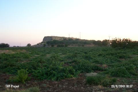 |
|
Type:
|
Mound |
|
Altitude:
|
720 m |
|
Region:
|
Southeastern Anatolia |
|
Province:
|
Kilis |
|
District:
|
Merkez |
|
Village:
|
Öncüpinar |
|
Investigation Method:
|
Excavation |
|
Period:
|
|
|
|
|
 |
|
| The mound lies 2.4 km south of Kilis; on Kilis-Öncüpınar motorway and has a height of 30 m. Soil taken from its eastern part forming a section in north-south direction and almost half of the mound is gone. There is a gendarme station on top of the mound because of Syrian border south of it. There are destructed graves at the skirts of the mound. These graves have two rooms with rough stone walls which become narrow to ceiling. The single line of stone closes the grave and formes the ceiling. The grave is 215 m below the surface and has a width of 2 m. Some the graves changed and used for the second time. The graves are dated to EBA according to the grave goods. The site has been excavated in 1984-85 fof two seasons. It is revisited in 2000 by E. Özgen and his team during the survey. The surface find are dated to Obaid Period and Late Chalcolithic. It takes place in the registered archaeological sites list prepared by Ministry of Culture and Tourism. |
| Location: |
| Geography and Environment: |
| History: |
| Research and Excavation: |
| Stratigraphy: |
| Small Finds: |
| Remains: |
| Interpretation and Dating: |