|
©The Archaeological Settlements of Turkey - TAY Project
|
|
|
|
|
|
Bagbasi |
|
|
For site maps and drawings please click on the picture...  |
For photographs please click on the photo... 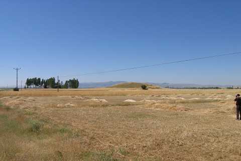 |
|
Type:
|
Mound |
|
Altitude:
|
25 m |
|
Region:
|
Mediterranean |
|
Province:
|
Antalya |
|
District:
|
Elmali |
|
Village:
|
Bagbasi |
|
Investigation Method:
|
Excavation |
|
Period:
|
EBA I EBA II |
|
|
|
 |
|
| It is close to Elmali; to the southwest of Antalya. It was discovered by M.J. Mellink who was conducting excavations and researches in the region. The excavations of the mound were carried out between 1967 and 1969. Only a 100x100 m portion of the whole settlement was excavated. The lower levels here have yielded structures belonging to EBA I. These structures are hut type buildings with a thin layer of plaster on the outside. They have stone foundations and rectangular plans. There are clay hearths with a diameter of 120 cm inside the buildings. Sherds of spouted pitchers and storage jars made of coarse grey clay were found in these structures. These hand-made sherds have similarities with Kusura A phase. Small metal fids such as awls and needles were also encountered. Terra cotta spindle whorls and animal figures were found. The upper layer includes architectural remains dating to EBA II. The construction technique here is different than the lower levels. The ceramics have the features of EBA I. |
| Location: It is located 1.5 km east of the Korkuteli-Elmali road; 7 km east-northeast of Elmali; southwest of Antalya. |
| Geography and Environment: The mound lies on the edge of a natural hill overlooking the Elmali plain. The western side of the hill is lower than the plain level while the eastern side is higher. There is a stream on the northern section that flows even in summer. The surface of the settlement is mixed by plowing. In the southern section of the well-watered plain are the Karagöl Sazligi and Avlan Lake which are almost dried. |
| History: |
| Research and Excavation: |
| Stratigraphy: |
| Small Finds: |
| Remains: |
| Interpretation and Dating: |