|
©The Archaeological Settlements of Turkey - TAY Project
|
|
|
|
|
|
Bahadirli |
|
|
For site maps and drawings please click on the picture...  |
For photographs please click on the photo... 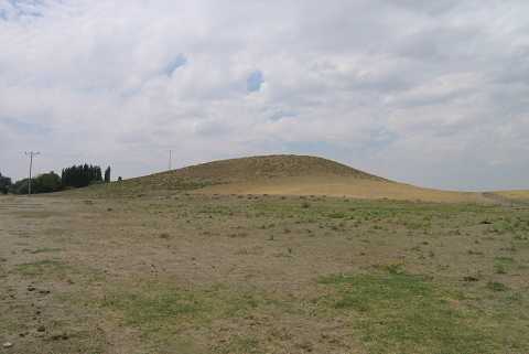 |
|
Type:
|
Mound |
|
Altitude:
|
1040 m |
|
Region:
|
Central Anatolia |
|
Province:
|
Konya |
|
District:
|
Kulu |
|
Village:
|
Bahadirli |
|
Investigation Method:
|
Survey |
|
Period:
|
|
|
|
|
 |
|
| It is 800 m north of the village of Bahadirli; 7 km southwest of the district of Kulu in the province of Konya. The mound measures 260 m in diameter; 22 m in height and a stream flows on its southern foot. It was discovered in 1992; during the survey of Central Anatolia conducted by S. Omura. The majority of the surface finds belongs to the first millennium BC but a small number of EBA materials were collected. It was researched again during the survey by S. Omura in 2004. The dimensions of the mound are: 119 m in north-south direction, 152 m in east-west direction, it is 16 m high. Roman period material were collected from the surface of the mound [Omura 2008:213; 218]. It is listed in the registered archaeological sites inventory prepared by Ministry of Culture and Tourism. It was visited during the survey conducted by H. Bahar and his team in 2012. During this survey, Bahar stated that the mound measures 100x100x25 m. Potsherds belonging to EBA, 2nd millennium BC, IA, Hellenistic and Roman periods were determined [Bahar 2014:261]. |
| Location: |
| Geography and Environment: |
| History: |
| Research and Excavation: |
| Stratigraphy: |
| Small Finds: |
| Remains: |
| Interpretation and Dating: |