|
©The Archaeological Settlements of Turkey - TAY Project
|
|
|
|
|
|
Bayrakli |
|
|
For site maps and drawings please click on the picture...  |
For photographs please click on the photo... 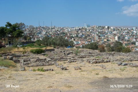 |
|
Type:
|
Mound |
|
Altitude:
|
40 m |
|
Region:
|
Aegean |
|
Province:
|
Izmir |
|
District:
|
Merkez |
|
Village:
|
|
|
Investigation Method:
|
Excavation |
|
Period:
|
Late |
|
|
|
 |
|
| The site is located northeast of the city of İzmir; at the shore of the old gulf. It appears at the map of the Chalcolithic Age sites of Southwestern Anatolia by J. Mellaart. Bayrakli is a debatable site for the Chalcolithic Age. |
| Location: It is located inside the metropolis of Izmir on the northeast. It could have been saved from a severe damage only after being announced as a registered site. It is also known as Tepekule. |
| Geography and Environment: It is situated east-northeast of the Izmir Gulf. It is 14 m high. To the west flows the stream of Meles. Today the site is far from the shoreline. However; it is suggested that it used to be on the coast during the settlements with two ports on both sides of an outcrop [Akurgal 1983:fig.1-2]. Eventually; it was abandoned since it was close to the swamp. The rock underneath is 6.4 m high. |
| History: |
| Research and Excavation: |
| Stratigraphy: |
| Small Finds: |
| Remains: |
| Interpretation and Dating: |