|
©The Archaeological Settlements of Turkey - TAY Project
|
|
|
|
|
|
Asagi Salat |
|
|
For site maps and drawings please click on the picture...  |
For photographs please click on the photo... 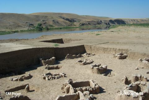 |
|
Type:
|
Mound |
|
Altitude:
|
490 m |
|
Region:
|
Southeastern Anatolia |
|
Province:
|
Diyarbakir |
|
District:
|
Bismil |
|
Village:
|
Yukari Salat |
|
Investigation Method:
|
Excavation |
|
Period:
|
|
|
|
|
 |
|
| Location: It is located 3 km south of Yukari Salat Beldesi; 3 km east of the district of Bismil in the province of Diyarbakir. Asagi Salat quarter of the Yukari Salat lies over the mound. The mound is on the bank of the Tigris River; 2 km east of the point where it joins the Salat stream. |
| Geography and Environment: The mound lies on an area fed by Tigris and its tributaries. Between Diyarbakir and Batman; the basin of Tigris is about 500 m high from the sea level. The road of Salat valley passes over Tigris in Asagi Salat and heads towards east and south. The mound; which lies beneath the quarter of Asagi Salat; measures about 150x100 m. It lies on a terrace that is about 3 m above the present river level. The cultural deposit of the site is about 5 m high in the middle section of the modern settlement. The southern section of the mound is destructed by the inundation of Tigris. |
| History: |
| Research and Excavation: Asagi Salat was first discovered by the surveys of G. Algaze and his team in 1989 [Algaze et al.1991:213]. Within the scope of the METU TAÇDAM Salvage Project of the Archaeological Heritage of the Ilisu and Carchemish Dam Reservoirs; a more intensive survey was conducted in 1999 by E. Ay [Ay 2001:717;718]. In 2000; as a part of the same project; an excavation was conducted under the directorship of N. Inal; Director of Diyarbakir Museum; and Y. Senyurt from the history Department of Gazi University. It takes place in the registered archaeological sites list prepared by Ministry of Culture and Tourism. |
| Stratigraphy: The excavation was carried out in four different areas: East Excavation Area; Central Excavation Area; Northeast Sounding and West Sounding. While two Medieval layers were determined in East Excavation area; Central Excavation Area has yielded three. No traces of settlement were found in the Northeast Sounding. In West Sounding; were found stone foundations belonging to Level I and beneath them; about 1.5 m under the surface; Early Bronze Age graves were encountered. |
| Small Finds: Beneath the stone foundations of Level I; a total of four graves were uncovered. The graves M-3; M-4 and M-5 are cist graves. The floors of these graves were laid with greenish pebbles and the four sides were formed single limestone slabs. Wide cover stones; partially broken; were placed on the top. The capping stones were secured by groups of smaller stones placed around the grave. The rectangular cist graves measure between 1.20-1.30 m in length and 1-1.10 m in width. Grave M-6 consists of medium-sized stones in an oval arrangement that cover the large cover stone. This grave; with no stones found at its northwest side; is not a cist grave like the others. The floor was laid with pebbles and it was covered with a stone. The average depth of the graves is 50-70 cm. The limestone slabs were neatly cut and are 5-7 cm thick. All the graves had been robbed. The cover stone and the slab at the east side of grave M-3 had been lifted completely and the grave was damaged. Outside the south wall of the grave and 30 cm to its north; vessels were encountered. The cover stones of graves M-4 and M-5 were broken at their southeast corners. All four of the graves have the same northwest-southeast orientation and their sizes are suitable for the burials in the hocker position. The exact position of the burials is uncertain because there was no skeletal remains found. However; the skull remains were found at the east end of the graves M-4 and M-5 and the east parts of the cover stones were broken considering that the valuable grave goods must have been placed near the head of the skeleton. According to this and the similarities with the Birecik cemetery; it is suggested that the skeletons were positioned with their heads at the east and feet at the west. These graves; which appear to have been robbed either during their period or immediately afterwards; yielded pottery; bronze pins and beads fashioned from mountain crystal. Two of the vessels of grave M-3 were thrown outside the grave and the other four were found inside; probably in situ. A buff-colored fruit-stand with broken pedestal was found just outside the grave M-3 and is a common type of the Early Bronze Age. The buff and beige colored biconical vases with string holes and the beige colored bowls display characteristics of Ninevite V Ware. None of the vessels have reserved slip [Senyurt 2002a:694-695] [Senyurt 2002b:447]. Including the graves uncovered in the 2002 season; a total of 44 graves have been found in the Early Bronze Age cemetery. All have a pebble floor and an east-west orientation with a slight deviation. The graves generally resembled the stone cist grave type; but there were also graves that did not altogether bear the characteristics of cist graves; and it is thought that these probably belonged to individuals of a lower social status. Instead of the sides of these graves being built from stone slabs; the burials were surrounded by stone rubble; and there was a stone cover over the grave. A common feature of all the graves was a floor of small pebbles [Senyurt 2002c]. |
| Remains: |
| Interpretation and Dating: The Asagi Salat examples of the rectangular cist graves; which are found in a wide area from Western Anatolia to Northern Mesopotamia throughout the Early Bronze Age; are parallel to the graves of Birecik Dam and Arslantepe. According to the ceramic finds; especially the Ninevite V Ware; the site was assigned to the beginning of the Early Bronze Age and it was determined that these vessels indicate a continuation of Late Uruk ceramic tradition. With this evidence; it is believed that Asagi Salat will throw a significant light on the link between the Late Uruk Period and the Ur Dynasty I Period in Northern Mesopotamia [Senyurt 2002a:695;696]. A piece of brick found in 2002 to the southeast of an EBA I grave suggests that there may be other graves dating to the 1st millennium BC; in the Asagi Salat cemetery area [Senyurt 2002c]. |