|
©The Archaeological Settlements of Turkey - TAY Project
|
|
|
|
|
|
Yogunhasan Kalesi |
|
|
For site maps and drawings please click on the picture...  |
For photographs please click on the photo... 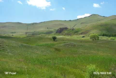 |
|
Type:
|
Slope Settlement |
|
Altitude:
|
1660 m |
|
Region:
|
Eastern Anatolia |
|
Province:
|
Kars |
|
District:
|
Sarikamis |
|
Village:
|
Karapinar |
|
Investigation Method:
|
Survey |
|
Period:
|
|
|
|
|
 |
|
| It is located in Altçayirlik Mevkii; on the northern slope of Kondol Hill; 3.6 km west of the village of Karapinar; 40 km southwest of the district of Sarikamis in the province of Kars. It was discovered in 2001 by A. Ceylan of Atatürk University during the survey of Erzincan; Erzurum and Kars provinces. It is reported that the site was inhabited during EBA and Iron Age and a Urartian rock tomb was also encountered. |
| Location: It is situated at Altçayirlik Mevkii on the northern slope of the Kondol Hill, 3.6 km west of the Karapinar (Yogunhasan) Village, 40 km southwest of the Sarikamis Village in Kars. |
| Geography and Environment: The fortress is on the northern skirt of the Aras Güneyi Mountains, 1.5 km south of the Aras River. It is at the cross roads of historical trade routes from Caucasia strecthing into the Anatolia to cities such as Kars, Sarikamis, Horasan, Hasankale, Erzurum, Erzincan and Sivas, and from India, Afghanistan, Northwest Iran, Nakchivan, Igdir, and Kagizman. To the northwest is a water spring. In 1/25.000 scale maps, it appears as "Kale Tepe". |
| History: |
| Research and Excavation: |
| Stratigraphy: |
| Small Finds: |
| Remains: |
| Interpretation and Dating: |