|
©The Archaeological Settlements of Turkey - TAY Project
|
|
|
|
|
|
Kara Mustafa Pasa Höyük |
|
|
For site maps and drawings please click on the picture...  |
For photographs please click on the photo... 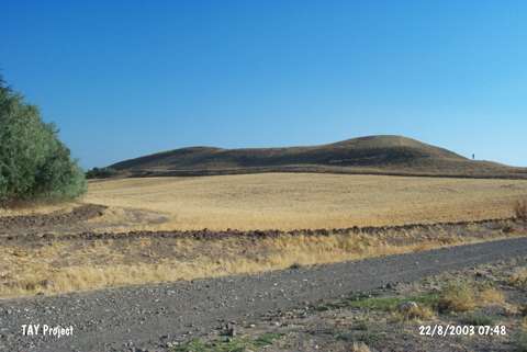 |
|
Type:
|
Mound |
|
Altitude:
|
736 m |
|
Region:
|
Black Sea |
|
Province:
|
Amasya |
|
District:
|
Merzifon |
|
Village:
|
Bahçekent |
|
Investigation Method:
|
Survey |
|
Period:
|
|
|
|
|
 |
|
| It lies about 2 km northeast of the village of Kara Mustafa Pasa (old Marinca; Bahçekent); in the district of Merzifon; province of Amasya. The mound; located 5 km northeast of Merzifon; measures 100x150 m in diameter and 35 m in height; and lies on a natural ridge. Merzifon-Samsun motorway passes from the southeast of the site. To the northeast flows the Boyaçukuru stream which has dried. The surface of the partly destructed settlement has yielded Late Chalcolithic and EBA ceramics. |
| Location: |
| Geography and Environment: |
| History: |
| Research and Excavation: |
| Stratigraphy: |
| Small Finds: |
| Remains: |
| Interpretation and Dating: |