|
©The Archaeological Settlements of Turkey - TAY Project
|
|
|
|
|
|
Gümüspinar |
|
|
For site maps and drawings please click on the picture...  |
For photographs please click on the photo... 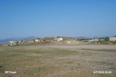 |
|
Type:
|
Mound |
|
Altitude:
|
1710 m |
|
Region:
|
Eastern Anatolia |
|
Province:
|
Mus |
|
District:
|
Bulanik |
|
Village:
|
Gümüspinar |
|
Investigation Method:
|
Survey |
|
Period:
|
|
|
|
|
 |
|
| The site is located immediately southwest the village of Gümüspinar (Pulur/Pülür); 12 km from the district of Bulanik; northeast of Mus Province. It is included in the EBA settlements of Eastern Anatolia by C.A. Burney and reported to be measuring 15 m in height and 150x100 m in diameter. However; during the researches conducted by Özfirat in 1998; its measurements were determined as 30 m in height and 300x250 m in diameter. The geographical features of the area probably caused these two different results. Today; the mound is partially covered by the modern village and there is a survey point on top hill. Rothman; who also conducted a survey in the region; doesn't refer to this mound that was named as Pulur by Burney. According to the materials collected; it is suggested that the mound was inhabited from the Early Bronze Age to the Medieval Age. Typical black polished Karaz Ware sherds with Nakhichevan/Nahçevan type handles and spiral decorations were collected. The sherds have close similarities with the ones gathered from the other mounds of the region. The site is re-studied by Biber-Çavusoglu during the survey initiated in 2009 and planned to last five years. The mound is measured as 250 m wide in North-South, and 185 m wide in East-West. The height of the site is 20 m in the North and 10 m in the South. The mound has a flat-conical shape and is flatter in the South and East and steep in the North and West [Biber-Çavusoglu 2011:203]. |
| Location: |
| Geography and Environment: |
| History: |
| Research and Excavation: |
| Stratigraphy: |
| Small Finds: |
| Remains: |
| Interpretation and Dating: |