|
©The Archaeological Settlements of Turkey - TAY Project
|
|
|
|
|
|
Bakla Tepe |
|
|
For site maps and drawings please click on the picture...  |
For photographs please click on the photo... 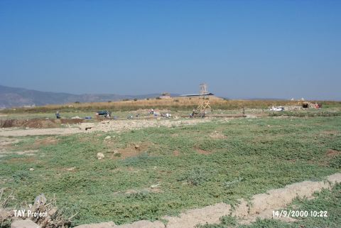 |
|
Type:
|
Mound |
|
Altitude:
|
70 m |
|
Region:
|
Aegean |
|
Province:
|
Izmir |
|
District:
|
Menderes |
|
Village:
|
Bulgurca |
|
Investigation Method:
|
Excavation |
|
Period:
|
EBA I EBA II |
|
|
|
 |
|
| Location: It is the rocky hill located immediately north of the village of Bulgurca Çiftlik which was removed in 1998 because of Tahtali Dam; about 30 km south of Izmir Province. The site is locally known with this name due to the broad bean cultivation [Erkanal-Özkan 1997: 262]. As a result of the small soundings it was understood that the prehistoric settlements on this rocky hill on the eastern bank of Bulgurca Stream continues beneath the village [Erkanal-Özkan 2000:263]. |
| Geography and Environment: The natural hill; which gradually rises from east to west; immediately descends and forms a steep slope to the east and measures about 20 m in height and 250 m in diameter; is a perfect homeland with the fertile lands of Tahtali Stream to its west and Cumaovasi. Over the hill is a flat area measuring 70 m in diameter. The fact that Cumaovasi plain; which is rich in water sources; has a depression in this area that resembles a lake bed; shows that there might be a fresh water lake during the periods of these settlements. The plain joins the gulf by extending towards north to Izmir; and the Küçük Menderes Valley by extending towards southeast to Torbali. Tahtali Stream passes from between the hills to the southwest and flows into the Gümüldür bay. It can be suggested that during the 4th and 3rd millennia BC; the rocky hill was located on the maritime trade line; in an area surrounded by gulfs and bays. The existence of rich finds can be linked to this trade. The hill was severely damaged during the 1st World War. A large pit was formed on the western section by a cannon ball. This pit was filled by the villagers with the soil carried from the Classical Period settlement nearby and this has caused a confusion in the stratigraphy at the beginning of the excavations [Erkanal-Özkanli 1997:263]. The recent investigations have also shown that the foundations of the village houses partially damaged the settlement remains beneath. |
| History: |
| Research and Excavation: It was discovered in 1984 by N. Tuna under the name of Bulgurca and introduced among the settlements of the third millennium BC [Tuna 1986:215]. Later; pottery of Kumtepe Ib was collected from the surface during a survey conducted by R. Meriç [Meriç 1987:302] The excavation conducted by H. Erkanal and T. Özkan within the context of the Salvage Project of the Tahtali Dam between 1995-1998 since it was noted that the dam would have influenced the mound and it would have ended in an island 5 m high. It takes place in the registered archaeological sites list prepared by Ministry of Culture and Tourism. |
| Stratigraphy: The excavation has laid out that the site had been occupied by a settlement of 250-300 m in diameter during the Late Chalcolithic Age; of ca. 90 m in diameter during the EBA I and by scattered settlements during EBA II. Also; a small Roman Period settlement was uncovered in the area used for king's tombs during the second millennium BC. The inhabitants of EBA I buried their dead into the slopes of the hill (extramurally) outside the city wall next to the settlement. The architectural remains yielded the presence of several building levels during the EBA I. A series of soundings were carried out in order to verify the size of the settlements. These soundings revealed that the cemeteries covered a larger area. An obsidian atelier was discovered on the south. |
| Small Finds: Architecture: The architecture of EBA I was revealed on the highest part of the hill in the undestroyed parts of the mound by the soldiers. The thick stone wall uncovered on the northern and eastern slopes is considered as a fortification wall. The construction of the wall is not neat; as it is the case in the houses. Various sizes of quarry stones were employed. The substructure of the wall is enlarged on both sides. The thickness is ca. 270-240 cm. Only a portion of 156 cm high survived to present day [Erkanal-Özkan 2000: 268; drw.3; pic.8]. Outside the eastern projection of the fortification wall; a ca. 340 cm thick ditch was opened into the Late Chalcolithic Age layers; and a blunt terrace wall of 210 m thick was built on the outer part of this ditch. By this way; the fortification was reinforced on the southern slope which is more flat than the other parts. Inside the fortification wall; a series of houses sharing party walls and having a length up to 20 m was uncovered. The houses are entered from 2 m wide stone paved streets. Their directions are different. Since the hill was not opened extensively; the settlement plan was not completely drawn. However presence of a radial system is suggested. These long buildings 4.5-5.8 m wide were separated into rooms by small walls for different functions. As far as the construction technique is concerned; the middle sized uneven stones were attached with loam mortar at least to form a faced wall. The thickness of the walls is between 60-80 cm. Only a portion of 2 m high survived to day; and they are suggested to be all built of stone. The long houses have big hearths ca. 1.8 m in diameter [Erkanal-Özkan 1999:339]. The floors are paved with stone. They share flat roofs. One of the houses; usually built in rectangular plan; has an apsidal structure; the short wall being rounded [Erkanal-Özkan 1998:409]. The presence of a silo; outside the houses; in almost a square plan (2x1.9 m) provides evidence about the socioeconomic life. In 1998; a thick-walled rectangular house of 910x410 cm was uncovered on the south of these houses. The function of this house couldn't not be identified; but proposed to be a significant structure. Scanty architectural remains of EBA II were uncovered on the eastern part of the hill. Pottery: EBA I: The building levels of this phase yielded vessels largely washed in black and gray; and rarely in brown and buff. Forms of carinated bowls with inverted rim; dishes and single handled mugs with flat rims are popular. Vertical handles; pierced lugs and tunnel handles are common. As decoration; painted; incised; jagged and relief decorations are applied. Filled in triangles; crossed lines; cage pattern; horizontal parallel lines were applied by matt white paint on black; brown or buff wash. The same patterns were employed for incised decorations. By jagged decoration; adjacent lines were applied. Samples of relief decorations are rare. Horseshoe; bulb and zigzag patterns are common. EBA II: Samples of gray ware are accompanied with the fine red and black washed ware [Erkanal-Özkan 2000:266]. Clay: Aside idols identical to the ones at Thermi II; plenty of spoons; likes found at Cyclades Islands; were recovered. Loomweights and spindle whorls evidence a heavy weaving industry. A clay idol was found in EBA II. Ground Stone: A marble idol; flat axes and a beautiful sample of shaft-holed axe were found in EBA I. In the EBA II settlement; very simple samples of idols with a strangle in the center were carved both into marble and other stones. Chipped Stone: Blades in obsidian and silex were recovered [Erkanal-Özkan 1997:270]. Bone: Aside plenty of awls and pins; an object looking like an idol was recovered. Metal: Slags and fragments of crucibles proved the dense mining activities of Baklatepe. A mould with a negative cavity for dagger production supports this thesis. Finds like copper/bronze chain and hair clip enrich the grave goods. A small silver pin is the oldest sample of its type; for now; in the region. Like of it was found in the Early Cyclades II at Naksos. EBA II settlement yielded plenty of bronze pins [Erkanal-Özkan 2000:267]. Human Remains: Intramural EBA I Graves: Limited number of intramural burials was found in the EBA I settlement on the uphill. The excavators report that it is difficult to differentiate them from the Late Chalcolithic Age graves. The 1998 excavation yielded a pithos grave probably dating from the EBA I. Extramural EBA I Cemetery: It is located outside the city walls on the eastern part of the hill. 14 graves were found until the end of the 1998 excavation. Three types of graves were uncovered; simple pit burials; pithos graves and cist graves. They don't have a specific order or lining. Adult and child graves as well as graves for rich and poor are in the same area; no separation was made. Some graves house more than one burial. Adults were usually buried in hocker position in the same direction (east-west direction); head oriented toward the west. The pithoi employed for burials; 180-190 cm high have a flaring rim; a short neck and a round bottom. Besides big sizes of 190x129 cm; there are small sized pithoi. Two or four handles for carriage were attached. Their mouths were capped by a flat stone or a broken sherd. One of the two cist graves belongs to a baby burial. They were built by standing the flat stones same as the other EBA graves. They were also capped by flat stones. The bigger grave measures 129x112 cm. Exposure of simple pit burials with rich grave goods evidence that the type of graves is independent of the wealth status. Some burials were interred in semi-hocker position. The grave goods were left at the foot and head of the burials. All types of graves include open jugs; small vessels; three footed jars; copper/bronze daggers; bracelets; earrings as well as precious finds like silver bracelets and necklace with silver beads; lead spirals. EBA II Graves: Only the pithos graves out of 64 graves uncovered on the southeastern part of the hill are claimed to belong to EBA II. The pithoi are in very bad conditions. Similar to EBA I graves; they were placed in the east-west direction and capped by flat stones or small stones after the dead was buried [Erkanal-Özkan 2000:draw.2; pic.1]. They house not only one burial; four; even six burials. Buried in hocker position; they are thought to be second burials. It is noted that the graves were arranged in order. Grave goods were left inside and outside the graves. Among them; a small vessel with a human face is an amazing find. A nearest sample to this was reported to be found at Karatas-Semayük. Also left are depas; three footed vessels; tankards; teapots and spouted pitchers [Erkanal-Özkan 2000:pic.2-5]. Some are produce of fast turning wheel. Objects like copper/bronze dagger; pin; terra cotta spindle whorl; stone spindle whorl were also found. The excavators date the cemetery to the end of the EBA II. |
| Remains: |
| Interpretation and Dating: Erkanal and Özkan report that the settlement plan of EBA I consists of long houses opening to stone paved streets in a radial plan; adopting the plans of the contemporary settlements of Anatolia and the Aegean Islands (e.g.; Beycesultan; Thermi II); and they date Baklatepe to the end of EBA I. It greatly resembles the settlement of Thermi [Erkanal 1996:74]. The exposure of fortification walls during the 1997-98 excavations was not amazing. The EBA II settlement was uncovered only in few places since it was severely damaged. Baklatepe; particularly the graves of Baklatepe; has the capacity to illuminate the Western Anatolian/ Aegean archaeology. It is unfortunate that the site was influenced by the Tahtali Dam. |