|
©The Archaeological Settlements of Turkey - TAY Project
|
|
|
|
|
|
Bakla Tepe |
|
|
For site maps and drawings please click on the picture...  |
For photographs please click on the photo... 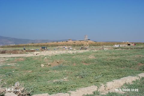 |
|
Type:
|
Mound |
|
Altitude:
|
70 m |
|
Region:
|
Aegean |
|
Province:
|
Izmir |
|
District:
|
Menderes |
|
Village:
|
Bulgurca |
|
Investigation Method:
|
Excavation |
|
Period:
|
Late |
|
|
|
 |
|
| It is the rocky hill located immediately north of the village of Bulgurca Çiftlik which was removed in 1998 because of Tahtali Dam; about 30 km south of Izmir Province. Tahtali (Derebogazi) Stream flows near the site. Because of the construction of a dam; excavations by H. Erkanal and T. Özkan were started in 1995. The site was discovered by N. Tuna in 1984; and it was named as Bulgurca Höyügü. In addition; R. Meriç made a survey and collected Late Chalcolithic Age sherds resembling the Kumtepe Ib finds. However; this occupation level (?) has not yet been found in the excavations. Code R 5 / 8. It takes place in the registered archaeological sites list prepared by Ministry of Culture and Tourism. |
| Location: It is the rocky hill located immediately north of the village of Bulgurca Çiftlik which was removed in 1998 because of Tahtali Dam; about 30 km south of Izmir Province. The site is locally known with this name due to the broad bean cultivation [Erkanal-Özkan 1997: 262]. As a result of the small soundings it was understood that the prehistoric settlements on this rocky hill on the eastern bank of Bulgurca Stream continues beneath the village [Erkanal-Özkan 2000:263]. |
| Geography and Environment: The natural hill; which gradually rises from east to west; immediately descends and forms a steep slope to the east and measures about 20 m in height and 250 m in diameter; is a perfect homeland with the fertile lands of Tahtali Stream to its west and Cumaovasi. Over the hill is a flat area measuring 70 m in diameter. The fact that Cumaovasi plain; which is rich in water sources; has a depression in this area that resembles a lake bed; shows that there might be a fresh water lake during the periods of these settlements. The plain joins the gulf by extending towards north to Izmir; and the Küçük Menderes Valley by extending towards southeast to Torbali. Tahtali Stream passes from between the hills to the southwest and flows into the Gümüldür bay. It can be suggested that during the 4th and 3rd millennia BC; the rocky hill was located on the maritime trade line; in an area surrounded by gulfs and bays. The existence of rich finds can be linked to this trade. The hill was severely damaged during the 1st World War. A large pit was formed on the western section by a cannon ball. This pit was filled by the villagers with the soil carried from the Classical Period settlement nearby and this has caused a confusion in the stratigraphy at the beginning of the excavations [Erkanal-Özkanli 1997:263]. The recent investigations have also shown that the foundations of the village houses partially damaged the settlement remains beneath. |
| History: |
| Research and Excavation: |
| Stratigraphy: |
| Small Finds: |
| Remains: |
| Interpretation and Dating: |