|
©The Archaeological Settlements of Turkey - TAY Project
|
|
|
|
|
|
Yukari Yarimca |
|
|
For site maps and drawings please click on the picture...  |
For photographs please click on the photo... 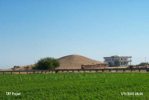 |
|
Type:
|
Mound |
|
Altitude:
|
370 m |
|
Region:
|
Southeastern Anatolia |
|
Province:
|
Sanliurfa |
|
District:
|
Harran |
|
Village:
|
Yukari Yarimca |
|
Investigation Method:
|
Survey |
|
Period:
|
Late |
|
|
|
 |
|
| The mound lies southeast of Sanliurfa; 8.5 km northwest of Harran; southeast of Yukari Yarimca village. It is an ovoid; conical mound with rather abrupt slopes; measuring 30 m in height and 100x60 m in diameter. The mound is discovered during the 1989 Sanliurfa Survey Project conducted by a team directed by N. Yardimci. Late Chalcolithic Age; EBA; MBA-LBA; IA; Antiquity and Islamic Period sherds are collected from the surface. Chalcolithic Age finds consist of straw tempered plain wares. It takes place in the registered archaeological sites list prepared by Ministry of Culture and Tourism. |
| Location: |
| Geography and Environment: |
| History: |
| Research and Excavation: |
| Stratigraphy: |
| Small Finds: |
| Remains: |
| Interpretation and Dating: |